July Summary
About average temperature, 341% of expected rainfall, 105% of average wind run.
(July compared to my records from the past 10 years.)
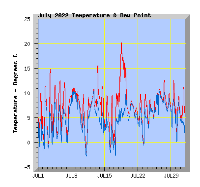
- July was close to average temperature of 6.8C with 6.7C.
- The coldest temperature was -2.8C, my average July minimum is -3.1C.
- The highest temperature was 20.2C, my average July maximum is 18.6C.
- Nine air frosts (air temperature at or below 0) were recorded, my average is 9.
- Thirteen days failed to reach 10C, my average is 10.
- Three days reached or exceeded 15C, my average is 5.
- One day reached or exceeded 20C, my average is 0. One other July day has reached or exceeded 20C. July 31 2014 recorded 21.4C
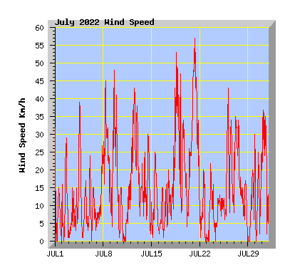
- Wind run was 105% of my average of 3516km with 3707km.
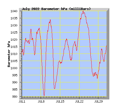
- The barometer recorded above average pressure for the month with 1013.6hPa. My average is 1012.9hPa.
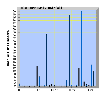
- Rainfall was 341% of the average expected total of 59mm with 200.2mm, making this July the wettest in my records.
- My previous July record was 167mm in 2017 caused flooding in the city.
- The wettest month in my records is June 2013 with 233mm
| July 2022 Summary Temperature | |
|---|---|
| Mean | 6.7 C |
| Mean Maximum | 11.2 C |
| Mean Minimum | 2.5 C |
| Maximum High | 20.2 C (18h) |
| Maximum Low | 7.6 C (8th and 27th) |
| Minimum High | 7.5 C (21st) |
| Minimum Low | -2.8 C (11th) |
| Wind Speed and Direction | |
| Maximum Gust | 57 km/h (21st) |
| Mean | 5.2 km/h |
| Wind Run | 3707 km |
| Max Daily Windrun | 396 km (21st) |
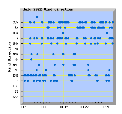
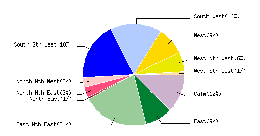
| Prevailing Direction | East North East |
| Barometer | |
| Maximum | 1040.3 hPa (23rd) |
| Minimum | 980.4 hPa (9th) |
| Mean | 1013.6 hPa |
| Max Daily Change | -40.8 hPa (12th) |
| Rainfall | |
| Days with Measured Rainfall (0.2mm or more) |
19 |
| Max Daily Rainfall | 50.0 mm (26th) |
| Monthly Rainfall | 200.2 mm |
| Humidity | |
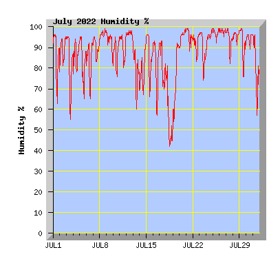
| Maximum | 100 % |
| Minimum | 41 % (18th) |
| July Daily Observations | ||||||||||||
|---|---|---|---|---|---|---|---|---|---|---|---|---|
| Temperature | Wind | Rainfall | Barometer | |||||||||
| Date | Min | Max | Mean | Mean (Km/h) | Gust (Km/h) | Run (km) | Prevailing Dir | 10 Minute Max (mm) | Total (mm) | Min (hPa) | Max (hPa) | Change (hPa) |
| 1 | -0.7 | 10.0 | 4.1 | 2.4 | 32 | 54 | East Nth East | 0.2 | 1.2 | 1008.8 | 1014.7 | +5.9 |
| Early showers clearing before dawn and the southerly wind dying out. A sunny day with a light NE wind. | ||||||||||||
| 2 | -1.2 | 11.4 | 5.0 | 3.3 | 29 | 75 | East Nth East | 0 | 0 | 1015.3 | 1021.1 | +5.8 |
| Morning frost, a few clouds but mostly sunny with a NE wind in the afternoon. | ||||||||||||
| 3 | -0.9 | 14.8 | 5.1 | 1.1 | 15 | 24 | East Nth East | 0 | 0 | 1017.1 | 1020.4 | +3.3 |
| Some morning cloud clearing by midday to a mild afternoon with light breezes tending NE. | ||||||||||||
| 4 | 1.1 | 11.6 | 6.2 | 5.5 | 39 | 126 | East Nth East | 0 | 0 | 1019.5 | 1027.7 | -8.2 |
| Sunny with a fresh NE wind from midday, dying out in the evening. | ||||||||||||
| 5 | 1.3 | 12.5 | 5.7 | 1.4 | 17 | 33 | East Nth East | 0 | 0 | 1008.9 | 1021.0 | -12.1 |
| Overcast with high cloud for much of the day. Cloud moving north and clearing in the afternoon. Light NE breezes. | ||||||||||||
| 6 | 0.8 | 12.1 | 7.2 | 2.7 | 24 | 61 | East Nth East | 0 | 0 | 1012.9 | 1027.0 | +14.1 |
| Morning cloud breaking to a sunny day with light NE breezes. | ||||||||||||
| 7 | -0.4 | 9.3 | 5.4 | 3.6 | 27 | 80 | West | 0 | 0 | 1018.6 | 1028.1 | -9.5 |
| Overcast and cool with a few spots of rain later in the afternoon. Light breezes turning NE in the evening. | ||||||||||||
| 8 | 7.6 | 11.2 | 9.8 | 9.3 | 45 | 212 | East Nth East | 0.8 | 13.2 | 982.2 | 1018.4 | -36.2 |
| Rain clearing in the afternoon but a few showers returning in the evening. NE wind. | ||||||||||||
| 9 | 5.7 | 10.3 | 8.3 | 8.3 | 48 | 189 | South West | 0.4 | 6.2 | 980.4 | 1015.6 | +35.2 |
| Overcast with rain from late morning, clearing in the evening. Southerly wind. | ||||||||||||
| 10 | -0.9 | 9.8 | 4.6 | 2.1 | 24 | 48 | South Sth West | 0 | 0 | 1015.8 | 1031.9 | +16.1 |
| Mostly cloudy but some sunny intervals from late morning. Light southerly wind. | ||||||||||||
| 11 | -2.8 | 9.2 | 3.4 | 1.3 | 17 | 31 | East Nth East | 0.2 | 0.6 | 1026.3 | 1034.1 | -7.8 |
| Morning frost then overcast and cold with light breezes tending NE. | ||||||||||||
| 12 | 6.9 | 10.8 | 8.4 | 11.2 | 43 | 256 | East | 0.8 | 34.6 | 985.3 | 1026.1 | -40.8 |
| Rain clearing in the evening with easterly wind turning southerly. Storm brings flooding, power outages and slips across NZ |
||||||||||||
| 13 | 5.9 | 15.6 | 9.5 | 5.7 | 28 | 130 | South Sth West | 0.2 | 0.2 | 985.5 | 996.5 | +11.0 |
| Morning cloud breaking and some sunny intervals around midday. Cloud increasing later in the afternoon with showers. | ||||||||||||
| 14 | 2.2 | 11.4 | 7.1 | 5.3 | 30 | 119 | South Sth West | 0.6 | 1.2 | 997.0 | 1005,6 | +8.6 |
| Partly cloudy with a southerly wind. A few showers at night. | ||||||||||||
| 15 | 1.4 | 9.6 | 5.1 | 3.8 | 25 | 86 | South Sth West | 0.2 | 0.4 | 1003.0 | 1007.6 | +4.6 |
| Morning cloud breaking with a light southerly wind. Cloud increasing in the afternoon with showers later. | ||||||||||||
| 16 | -1.4 | 9.5 | 2.5 | 1.3 | 15 | 30 | South Sth West | 0 | 0 | 1007.8 | 1018.6 | +10.8 |
| Morning frost, sunny with light a southerly wind. | ||||||||||||
| 17 | -2.4 | 10.0 | 4.9 | 3.4 | 20 | 76 | East Ntn East | 0 | 0 | 1014.9 | 1020.7 | -5.8 |
| Morning frost. High cloud increasing and becoming overcast by mid morning, light NE wind. Mt Cook drops to -11.6C, the coldest temperature recorded this year |
||||||||||||
| 18 | 5.6 | 20.2 | 14.4 | 9.6 | 53 | 219 | North Nth East | 0 | 0 | 1005.5 | 1015.2 | -9.7 |
| Mild with variable cloud and fresh to strong north to nor'west wind. Weather: 190kph gusts in parts of South Island, 3000 lightning strikes recorded |
||||||||||||
| 19 | 5.9 | 16.2 | 10.9 | 8.7 | 47 | 197 | West | 0 | 0 | 1005.2 | 1016.4 | +11.2 |
| Overcast with some light drizzle later in the afternoon. Variable winds tending westerly. Maximum temperature recorded at 10 past midnight when the wind was nor'west. 100-year rain event cuts off Aoraki/Mt Cook and Lake Ōhau villages |
||||||||||||
| 20 | 5.6 | 8.5 | 7.0 | 7.8 | 39 | 177 | South West | 0.4 | 3.8 | 1012.4 | 1018.9 | -6.5 |
| Some morning drizzle. Showers later in the afternoon, southerly wind. | ||||||||||||
| 21 | 4.2 | 7.5 | 6.2 | 17.3 | 57 | 396 | South West | 1.0 | 47.4 | 1012.4 | 1028.6 | +16.6 |
| Rain with strong southerly wind. Rain easing to showers later in the afternoon. No rain warning issued for Christchurch despite deluge resulting in widespread flooding |
||||||||||||
| 22 | 1.3 | 9.8 | 5.5 | 2.2 | 20 | 49 | South Sth West | 0.2 | 0.6 | 1028.7 | 1038.1 | +9.4 |
| Morning showers clearing, sunny intervals in the afternoon. Light southerly breezes. Risk of more flooding with Christchurch on track for its wettest July ever |
||||||||||||
| 23 | -0.6 | 9.7 | 4.8 | 2.1 | 22 | 48 | East Nth East | 0 | 0 | 1037.9 | 1040.3 | +2.4 |
| Morning cloud breaking, light NE wind. | ||||||||||||
| 24 | 3.1 | 8.8 | 6.0 | 1.8 | 13 | 41 | South Sth West | 0.2 | 0.4 | 1030.7 | 1038.5 | -7.8 |
| Overcast and damp with occasional drizzle and light breezes tending southerly. | ||||||||||||
| 25 | 5.1 | 9.6 | 6.7 | 3.5 | 31 | 80 | South Sth West | 1.0 | 12.2 | 1015.1 | 1030.6 | -15.5 |
| Occasional drizzle during the day, rain in the evening. Light southerly breezes turning NE for a time in the evening, recording the max temp for the day at 11pm. | ||||||||||||
| 26 | 5.3 | 10.8 | 9.0 | 7.2 | 43 | 164 | East | 1.4 | 50.0 | 995.2 | 1014.6 | -19.4 |
| Rain, heavy at times. Westerly winds turning easterly from mid morning and southerly in the evening. Flooding in several areas of Christchurch. In pictures: Low blasts into South Island, bringing widespread flooding and snow |
||||||||||||
| 27 | 7.6 | 12.7 | 9.3 | 10.9 | 35 | 247 | South West | 0.6 | 2.4 | 993.9 | 997.4 | |
| Showers clearing early morning. Cloud breaking but returning in the evening, cool southerly wind. | ||||||||||||
| 28 | 6.1 | 9.9 | 7.7 | 3.7 | 17 | 83 | South West | 0.2 | 1.0 | 992.6 | 997.3 | +4.7 |
| Overcast with occasional light showers, light southerly wind. Christchurch's flood defence system nearly overwhelmed in storm |
||||||||||||
| 29 | 2.1 | 12.6 | 7.0 | 2.8 | 30 | 63 | East Nth East | 0.2 | 0.2 | 997.2 | 1011.2 | +14.0 |
| Overcast with light showers. Cloud breaking later in the morning so a mostly sunny say with southerly wind turning NE. More rain expected in Canterbury just days after massive storm 'Quite exceptional' July dumps rain at record levels after weather change Warmer, drier weather on the way after record July rainfall |
||||||||||||
| 30 | 0.3 | 9.3 | 5.4 | 4.5 | 45 | 100 | East Nth East | 1.0 | 14.2 | 1004.9 | 1013.6 | -8.7 |
| Morning frost then overcast with light NE wind. Rain from around 4pm. | ||||||||||||
| 31 | 2.7 | 11.2 | 6.4 | 8.7 | 37 | 199 | South West | 0.8 | 9.4 | 1004.3 | 1016.5 | +12.2 |
| Morning rain clearing from late morning and cloud breaking. Southerly winds dying away in the evening. Heavy snow and rain closes South Island roads |
||||||||||||