October Summary
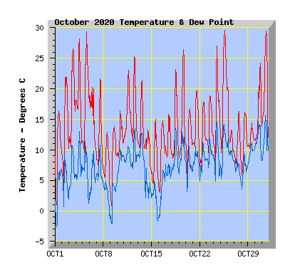
Record average temperature, just 29% of expected rainfall. This October set 2 records for maximum and and average temperature.
(October compared to my records from the past 10 years.)
- This October was above my average temperature of 12.0C with 13.0C, a new record October average temperature. The previous record was 2013 with 12.9C
- The warmest temperature was also recorded this October with 29.6C, my highest October temperature in the past 10 years and also my 20 years records
- The coldest temperature was 0.3C, a little lower than my average of 0.6C
- No days recorded an air frost (0c or below), my average is 1 day.
- No days failed to reach 10C, my average is 1.
- Twenty six days reached or exceeded 15C, my average is 23.
- Sixteen days reached or exceeded 20C, my average is 11.
- Eight days reached or exceeded 25C, my average is 3.
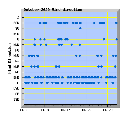
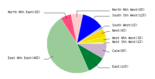
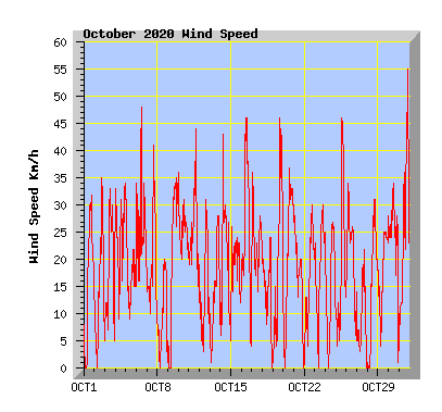
- Wind run was 94% of my average of 5032km with 4710km.
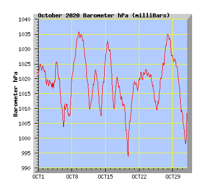
- The barometer recorded above average pressure for the month with 1018.8hPa. My average is 1010.0hPa.
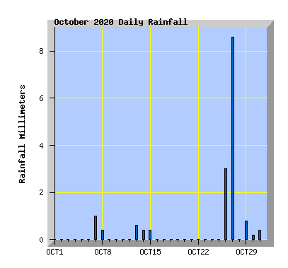
- Rainfall was 29% of the average expected total of 52mm with 15.5mm, the driest October since 2014 which had 14.5mm.
- The wettest October in the past 10 years is 2011 with 101.5mm.
- 2020 is now 282mm below the expected average rainfall total as at 31 October.
| October 2020 Summary Temperature | |
|---|---|
| Mean | 13.0 C |
| Mean Maximum | 20.5 C |
| Mean Minimum | 7.3 C |
| Maximum High | 29.6 C (25th) |
| Maximum Low | 11.6 C (11th) |
| Minimum High | 12.9 C (8th) |
| Minimum Low | 0.3 C (1st) |
| Wind Speed and Direction | |
| Maximum Gust | 55 km/h (31st) |
| Mean | 6.7 km/h |
| Wind Run | 4710 km |
| Max Daily Windrun | 243 km (16th) |
| Prevailing Direction | East North East |
| Barometer | |
| Maximum | 1035.8 hPa (9th) |
| Minimum | 993.6 hPa (19th) |
| Mean | 1018.8 hPa |
| Max Daily Change | +19.4 hPa (14th) |
| Rainfall | |
| Days with Measured Rainfall (0.2mm or more) |
10 |
| Max Daily Rainfall | 8.6 mm (27th) |
| Monthly Rainfall | 15.8 mm |
| Humidity | |
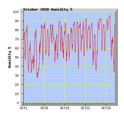
| Maximum | 96 % (30th) |
| Minimum | 27 % (5th) |
| October Daily Observations | ||||||||||||
|---|---|---|---|---|---|---|---|---|---|---|---|---|
| Temperature | Wind | Rainfall | Barometer | |||||||||
| Date | Min | Max | Mean | Mean (Km/h) | Gust (Km/h) | Run (km) | Prevailing Dir | 10 Minute Max (mm) | Total (mm) | Min (hPa) | Max (hPa) | Change (hPa) |
| 1 | 0.3 | 16.4 | 9.4 | 6.1 | 32 | 138 | East Nth East | 0 | 0 | 1021.6 | 1025.1 | +3.5 |
| Morning frost. Sunny with a few clouds and a NE wind. | ||||||||||||
| 2 | 2.9 | 22.1 | 13.3 | 4.5 | 35 | 102 | East Nth East | 0 | 0 | 1018.0 | 1024.1 | -6.1 |
| Sunny with NE winds turning NW form late afternoon. | ||||||||||||
| 3 | 9.4 | 26.6 | 17.3 | 5.7 | 33 | 130 | North Nth West | 0 | 0 | 1017.1 | 1019.5 | -2.4 |
| Sunny and warm with mostly light nor 'west winds. | ||||||||||||
| 4 | 10.7 | 28.2 | 17.3 | 8.1 | 34 | 186 | East Nth East | 0 | 0 | 1016.9 | 1025.8 | +8.9 |
| Some high cloud, warm northerly winds turning cooler westerly in the afternoon and then NE in the evening. Climate change: Study reveals where in NZ summer is growing longer |
||||||||||||
| 5 | 9.2 | 29.3 | 18.3 | 4.9 | 31 | 111 | East Nth East | 0 | 0 | 1009.6 | 1024.4 | -14.8 |
| Warm with high cloud, winds varying between NE and nor'west. | ||||||||||||
| 6 | 8.9 | 20.3 | 14.9 | 9.6 | 48 | 219 | East Nth East | 0 | 0 | 1003.8 | 1011.7 | -7.9 |
| Warm nor'west winds in the morning with the maximum temperature recorded at 9:40am. A cold southerly change around 10am with increasing cloud. A light shower with a wind change to NE in the afternoon. | ||||||||||||
| 7 | 6.8 | 21.6 | 11.3 | 6.7 | 41 | 153 | East Nth East | 0.4 | 1.0 | 1007.3 | 1020.1 | +12.8 |
| Sunny with light NE winds. A southerly change mid afternoon with cloud increasing in the evening and showers at night. | ||||||||||||
| 8 | 3.4 | 12.9 | 7.9 | 2.2 | 20 | 50 | East Nth East | 0.2 | 0.4 | 1021.4 | 1032.8 | +12.4 |
| Showers clearing by dawn. Cloudy and cool with light variable breezes turning NE in the afternoon. Climate: La Nina spells another dire summer for New Zealand's melting glaciers |
||||||||||||
| 9 | 0.4 | 13.8 | 7.8 | 8.1 | 35 | 185 | East Ntn East | 0 | 0 | 1033.0 | 1035.8 | +2.8 |
| Sunny with a few clouds, cool NE wind. | ||||||||||||
| 10 | 8.1 | 16.4 | 11.5 | 9.7 | 36 | 222 | East Nth East | 0 | 0 | 1024.3 | 1034.8 | -10.5 |
| Cloudy and cool with a NE wind, a few spots of rain through the afternoon and evening. | ||||||||||||
| 11 | 11.6 | 23.1 | 15.6 | 9.7 | 44 | 223 | East Nth East | 0 | 0 | 1009.6 | 1024.0 | -14.4 |
| Variable cloud with sunny intervals, mild in the afternoon with NE winds turning NNE. | ||||||||||||
| 12 | 10.6 | 25.3 | 15.3 | 4.1 | 31 | 92 | East Nth East | 0 | 0 | 1012.2 | 1023.0 | +10.8 |
| Some morning cloud then sunny and mild with light west to SW winds. Wind turning NE and strengthening in the afternoon with increasing cloud. | ||||||||||||
| 13 | 10.0 | 21.4 | 13.5 | 4.5 | 28 | 102 | East Nth East | 0.2 | 0.6 | 1008.1 | 1022.5 | -14.4 |
| Early showers clearing by dawn, sunny and mild with west to NW winds turning NE from mid afternoon. | ||||||||||||
| 14 | 5.8 | 13.3 | 9.9 | 6.0 | 43 | 137 | South Sth West | 0.2 | 0.4 | 1007.5 | 1026.9 | +19.4 |
| Cloudy and cool with a southerly wind dying away in the afternoon with light showers later. | ||||||||||||
| 15 | 3.9 | 15.0 | 7.5 | 6.1 | 26 | 137 | East Nth East | 0.2 | 0.4 | 1027.1 | 1032.7 | +5.6 |
| Morning cloud with a few showers clearing after midday with cloud breaking. Variable winds turning NE from mid afternoon. What will La Nina mean for fire danger this summer? |
||||||||||||
| 16 | 2.4 | 14.9 | 9.0 | 10.6 | 46 | 243 | East Nth East | 0 | 0 | 1009.9 | 1028.3 | -18.4 |
| Some cloud. Fresh cool NE wind easing in the afternoon. | ||||||||||||
| 17 | 8.6 | 15.8 | 10.9 | 9.6 | 36 | 215 | East Nth East | 0 | 0 | 1013.8 | 1020.5 | +6.7 |
| Mostly cloudy with fresh NE wind in the afternoon. | ||||||||||||
| 18 | 8.2 | 23.2 | 13.0 | 4.4 | 24 | 99 | East Nth East | 0 | 0 | 1010.1 | 1016.1 | -6.0 |
| Morning cloud clearing to a sunny and mild day with light winds. | ||||||||||||
| 19 | 8.3 | 26.4 | 14.4 | 6.9 | 46 | 158 | East Nth East | 0 | 0 | 993.6 | 1009.9 | -16.3 |
| Morning cloud breaking to a sunny and warm afternoon with northerly winds. A cooler southerly change arriving in the evening. | ||||||||||||
| 20 | 4.7 | 16.8 | 11.5 | 8.5 | 37 | 195 | East Nth East | 0 | 0 | 1005.2 | 1019.1 | +13.9 |
| Variable cloud but a mostly sunny afternoon with a NE wind Why NZ faces a higher risk of tropical cyclones this season |
||||||||||||
| 21 | 7.5 | 19.8 | 13.6 | 6.1 | 30 | 139 | East Nth East | 0 | 0 | 1015.9 | 1019.6 | +3.7 |
| Early drizzle clearing before dawn, cloud clearing to a sunny and mild afternoon. | ||||||||||||
| 22 | 6.4 | 17.8 | 11.7 | 5.8 | 30 | 133 | East Nth East | 0 | 0 | 1019.6 | 1022.5 | +2.9 |
| morning mist clearing. Variable cloud with NE wind | ||||||||||||
| 23 | 7.8 | 18.9 | 13.6 | 6.7 | 30 | 154 | East Nth East | 0 | 0 | 1020.9 | 1023.4 | -2.5 |
| Variable cloud but mostly sunny, NE wind. | ||||||||||||
| 24 | 6.2 | 27.0 | 15.3 | 4.8 | 27 | 107 | East Nth East | 0 | 0 | 1016.4 | 1021.5 | -5.1 |
| Sunny and warm with NE wind in the afternoon. | ||||||||||||
| 25 | 9.0 | 29.6 | 19.7 | 5.8 | 46 | 133 | East Nth East | 0 | 0 | 1009.2 | 1016.4 | -7.2 |
| Overcast with high cloud with warm nor 'west winds from midday. | ||||||||||||
| 26 | 9.3 | 20.3 | 12.2 | 7.9 | 34 | 179 | South Sth West | 0.4 | 3.0 | 1011.6 | 1025.4 | +13.8 |
| Overcast and cool with southerly winds, drizzle and light rain from evening. Maximum temperature recorded at 1am. | ||||||||||||
| 27 | 6.8 | 16.3 | 10.4 | 2.3 | 22 | 53 | South Sth West | 0.4 | 8.6 | 1024.5 | 1035.1 | +10.6 |
| Cloudy with light morning rain clearing by midday, light southerly winds. | ||||||||||||
| 28 | 5.6 | 16.2 | 11.0 | 6.0 | 31 | 138 | East Nth East | 0 | 0 | 1027.3 | 1035.0 | -7.7 |
| Cloudy morning, cloud breaking and clearing to a sunny afternoon with NE wind. | ||||||||||||
| 29 | 10.1 | 14.4 | 11.8 | 6.2 | 28 | 141 | East Nth East | 0.2 | 0.8 | 1023.1 | 1027.3 | -4.2 |
| Early rain. Low cloud with drizzle at times, NE wind. Why Aucklanders are in for a hot, wet and sticky summer |
||||||||||||
| 30 | 11.4 | 24.2 | 15.8 | 8.9 | 34 | 203 | East Nth East | 0.2 | 0.2 | 1008.6 | 1022.8 | -14.2 |
| Morning low cloud and drizzle. Cloud lifting and breaking and NE wind decreasing. Mild in the afternoon with light winds. | ||||||||||||
| 31 | 11.6 | 29.5 | 19.6 | 9.7 | 55 | 222 | East Nth East | 0.2 | 0.4 | 997.9 | 1009.1 | +11.2 |
| Cloud breaking mid morning to a sunny and warm day with north to nor'west wind, gusty in the afternoon. A cooler southerly change about 7:30pm with a few showers. | ||||||||||||