My July
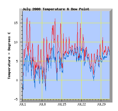
Temperature: My mean temperature for the month was 6.7C, this July was the second warmest I've recorded and equals the mean for July 2000. The highest temperature was 16.4C on the 2nd. I recorded just 4 days where temperatures were at or below 0C at some part of the day, the lowest total for any July I've recorded.July 2001 has my record of 23 days. My lowest July temperature to date is -6.9C on the 3rd July 2001, The warmest July temperature I've recorded was 19.6C on the 26th and 27th July 2007.
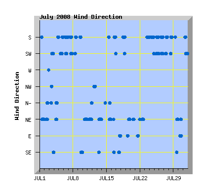
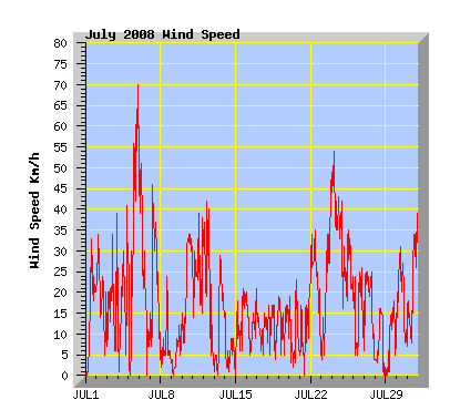
Wind: (Records from 2001) The monthly wind run of 4724km is the windiest July I have records for. The previous record was July 2005 with 3892km. The average July wind run is 3330km. The least windy July was 2007 with 2872km. Prevailing wind direction was north east recorded 33% of the month, south 31%, south west 19%, east 6%, north 5%, south east and north west 3% each. Maximum gust was 70km/h from the south on the 5th which is the highest wind gust recorded this year and is the 3rd highest gust I've recorded to date. The highest is 82km/h from the south on the 3rd March 2006.
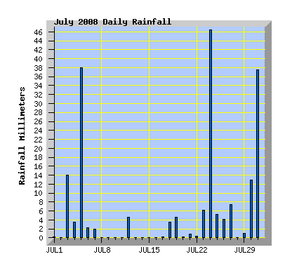
Rainfall: With 195.4mm, July was the wettest month of any I've recorded in 9 years of records and had nearly 4 times the average July rainfall. The previous monthly record total was May 2006 with 159.4mm. This July also recorded the highest daily July total with 46.4mm on the 24th. This July had 18 rain days, my July average is 11 and the average rainfall for July at my station is 54mm. The driest July I've recorded was 2000 with 18.8mm.
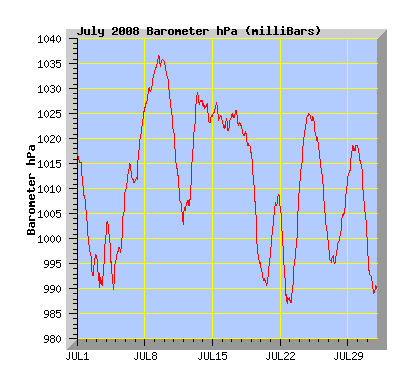
Barometer: (Records from 2006) The average pressure for this July was 1011.4 hPa, my July average is 1013.8. Maximum pressure was 1036.8, the highest I've recorded for July was 2006 with 1038.5. This July recorded the lowest pressure with 986.5 hPa.
| July 2008 Summary Temperature |
|
|---|---|
| Mean | 6.7 C |
| Mean Maximum | 10.8 C |
| Mean Minimum | 3.4 C |
| Maximum High | 16.4 C (2nd) |
| Maximum Low | 6.8 C (18th) |
| Minimum High | 6.1 C (5th) |
| Minimum Low | -2.8 C (1st) |
| Wind Speed and Direction | |
| Maximum Gust | 70 km/h (5th) |
| Mean | 6.4 km/h |
| Wind Run | 4724 km |
| Max Daily Windrun | 426 km (24th) |
| Prevailing Direction | North East |
| Barometer | |
| Maximum | 1036.8 hPa (9th) |
| Minimum | 986.5 hPa (22nd) |
| Mean | 1011.4 hPa |
| Max Daily Change | +23.6 hPa (23rd) |
| Rainfall | |
| Days with Measured Rainfall (Greater than 0.2mm) | 18 |
| Max Daily Rainfall | 46.4 mm (24th) |
| Monthly Rainfall | 195.4 mm |
| Humidity | |
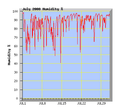
| Maximum | 99 % (Several Days) |
| Minimum | 40 % (14th) |
| July Daily Observations | ||||||||||||
|---|---|---|---|---|---|---|---|---|---|---|---|---|
| Temperature | Wind | Rainfall | Barometer | |||||||||
| Date | Min | Max | Mean | Mean (Km/h) | Gust (Km/h) | Run (km) | Prevailing Dir | 10 Minute Max (mm) | Total (mm) | Min (hPa) | Max (hPa) | Change (hPa) |
| 1 | -2.8 | 8.1 | 3.0 | 5.4 | 33 | 128 | North East | 0.2 | 0.2 | 1004.3 | 1017.6 | -13.3 |
| Frost. Some cloud, cool NE wind. (Rainfall recorded was frost melt.) | ||||||||||||
| 2 | 6.4 | 16.4 | 10.0 | 6.4 | 34 | 150 | North East | 0 | 0 | 992.4 | 1004.1 | -11.7 |
| Mostly cloud with north to NE winds. | ||||||||||||
| 3 | 4.8 | 15.5 | 9.4 | 4.1 | 39 | 98 | North East | 6.4 | 14.0 | 990.1 | 1001.3 | +11.2 |
| Mostly cloudy in the morning. Cloud breaking on the afternoon with north to NE winds. A thunderstorm in the evening with torrential rain and pea sized hail lasting about 30 minutes. The street here was white with hail and the downpour could be heard to the south 5 or more minutes before it arrived. | ||||||||||||
| 4 | 0.8 | 9.7 | 5.2 | 6.0 | 41 | 141 | North East | 0.6 | 3.6 | 989.9 | 1003.5 | -13.6 |
| Cloud increasing from morning with a few spots of rain in the afternoon. Showers at night with a southerly change. | ||||||||||||
| 5 | -0.7 | 6.1 | 2.7 | 17.3 | 70 | 408 | South West | 1.4 | 38 | 995.8 | 1009.7 | +13.9 |
| Broken cloud and a cold south westerly wind in the morning. Rain followed by snow falling just after noon and increasing wind speeds. Snow turned to rain late afternoon with an increase in temperature but the south west wind remained strong with a gust of 70km/h between 8:50 and 9pm, the strongest wind gust recorded this year and the strongest since 3 March 2006. Snow and ice caused major disruption to travellers on the roads in the North and South Islands as summarised in this NZ Herald story . | ||||||||||||
| 6 | 2.0 | 9.4 | 4.6 | 9.5 | 51 | 225 | South | 0.4 | 1.6 | 1009.4 | 1015.1 | +5.7 |
| Early morning showers. Cloud breaking late morning. Cold southerly wind. | ||||||||||||
| 7 | 0.2 | 8.1 | 4.3 | 9.0 | 46 | 212 | South | 0.6 | 2.0 | 1011.6 | 1026.1 | +14.5 |
| Morning showers and cold southerly winds. Cloud breaking and the showers clearing by midday. | ||||||||||||
| 8 | -0.1 | 11.0 | 4.0 | 1.7 | 24 | 41 | South | 0 | 0 | 1026.1 | 1033.1 | +7.0 |
| Cloud clearing to a sunny day with light southerly winds. | ||||||||||||
| 9 | -2.3 | 11.3 | 3.9 | 1.3 | 15 | 31 | South | 0 | 0 | 1033.3 | 1036.8 | +3.5 |
| Cloud breaking early afternoon, light southerly winds. | ||||||||||||
| 10 | 4.4 | 9.7 | 7.1 | 9.6 | 34 | 228 | North East | 0 | 0 | 1021.3 | 1035.5 | -14.2 |
| Broken cloud with a cool NE wind. | ||||||||||||
| 11 | 4.3 | 14.4 | 10.4 | 9.5 | 39 | 222 | North East | 0 | 0 | 1002.7 | 1021.5 | -18.8 |
| Broken cloud with NE winds turning more northerly from evening. The days maximum temperature recorded at 11:40pm. | ||||||||||||
| 12 | 4.5 | 16.1 | 11.0 | 7.1 | 42 | 168 | North West | 1.0 | 4.6 | 1003.4 | 1018.6 | +15.2 |
| Early morning showers with nor'west winds easing during the day. Mostly sunny with some cloud in the afternoon. | ||||||||||||
| 13 | 0.1 | 11.8 | 6.7 | 4.8 | 29 | 112 | North East | 0 | 0 | 1019.1 | 1029.3 | +10.2 |
| Sunny with NE winds. | ||||||||||||
| 14 | 2.4 | 14 9 | 7.5 | 0.7 | 15 | 16 | North | 0 | 0 | 1022.8 | 1027.3 | -4.5 |
| Sunny with thin high cloud, little wind. | ||||||||||||
| 15 | 2.7 | 12.2 | 6.0 | 4.7 | 21 | 111 | North East | 0 | 0 | 1023.8 | 1027.3 | -3.5 |
| Some high cloud and light winds for much of the day. Cooler NE winds bringing low cloud later in the afternoon. | ||||||||||||
| 16 | 6.6 | 11.2 | 7.9 | 4.2 | 21 | 99 | South | 0 | 0 | 1021.7 | 1024.7 | +3.0 |
| Mostly cloudy with southerly breezes from afternoon. | ||||||||||||
| 17 | 6.6 | 11.4 | 8.2 | 3.5 | 15 | 83 | South | 0.2 | 0.2 | 1022.7 | 1025.9 | -3.2 |
| Low cloud with some drizzle, cool southerly breeze. | ||||||||||||
| 18 | 6.8 | 9.2 | 8.2 | 4.1 | 17 | 97 | South | 0.4 | 3.6 | 1017.3 | 1022.6 | -5.3 |
| Light rain and drizzle in the morning. Dull with low cloud and a southerly breeze. | ||||||||||||
| 19 | 6.6 | 9.6 | 7.5 | 3.9 | 19 | 92 | North East | 1.2 | 4.6 | 994.6 | 1016.9 | -22.3 |
| Dull with low cloud, drizzle and showers in the morning, light winds. | ||||||||||||
| 20 | 4.6 | 15.2 | 7.6 | 2.8 | 23 | 67 | North East | 0.2 | 0.2 | 990.5 | 997.2 | +6.7 |
| Broken cloud with light breezes on the morning, cooler NE wind in the afternoon. | ||||||||||||
| 21 | 4.9 | 14.8 | 8.6 | 3.6 | 24 | 85 | East | 0.2 | 0.8 | 997.5 | 1009.0 | +11.5 |
| Morning cloud breaking to a sunny afternoon with light winds. | ||||||||||||
| 22 | 4.8 | 12.0 | 8.9 | 8.6 | 35 | 203 | North East | 0.2 | 0.4 | 986.5 | 1006.3 | -19.8 |
| Morning showers. Cloud breaking late morning but returning in the evening. NE winds. | ||||||||||||
| 23 | 4.9 | 8.7 | 7.3 | 10.5 | 49 | 247 | South | 0.8 | 6.2 | 987.2 | 1010.8 | +23.6 |
| Overcast with north to NE winds in the morning, turning southerly later with rain. | ||||||||||||
| 24 | 4.0 | 7.0 | 6.0 | 18.0 | 54 | 426 | South | 1.2 | 46.4 | 1011.0 | 1025.2 | +14.2 |
| Overcast with cold southerly winds and rain. | ||||||||||||
| 25 | 2.6 | 6.9 | 4.1 | 10.1 | 35 | 240 | South West | 1.4 | 5.0 | 1018.3 | 1025.0 | -6.7 |
| Low cloud, showers and cold southerly winds. | ||||||||||||
| 26 | 0.4 | 7.0 | 4.1 | 5.3 | 26 | 125 | South | 0.4 | 4.2 | 998.5 | 1018.3 | -19.8 |
| Snow on the Port Hill melting by afternoon. Mostly cloudy with southerly winds. Light rain from evening. | ||||||||||||
| 27 | 4.4 | 8.1 | 5.9 | 7.5 | 25 | 178 | South | 0.4 | 7.2 | 995.0 | 999.3 | +4.3 |
| Low cloud with showers and drizzle, southerly winds. | ||||||||||||
| 28 | 3.4 | 9.5 | 5.8 | 2.2 | 16 | 54 | South | 0 | 0 | 999.3 | 1012.2 | +12.9 |
| Mostly cloudy with some drizzle, cloud breaking toward evening. Light southerly winds. | ||||||||||||
| 29 | 5.3 | 11.2 | 6.9 | 2.2 | 18 | 51 | North East | 0.4 | 1.0 | 1012.2 | 1019.0 | +6.8 |
| Morning rain and drizzle. Cloud breaking and some sunny intervals. Light winds. | ||||||||||||
| 30 | 6.5 | 8.9 | 7.5 | 5.6 | 31 | 133 | North East | 0.6 | 13.0 | 997.0 | 1018.3 | -18.6 |
| Cloudy with east to NE winds, rain from late afternoon. | ||||||||||||
| 31 | 6.4 | 8.9 | 7.8 | 10.1 | 39 | 238 | South West | 1.0 | 37.2 | 989.1 | 999.0 | -9.9 |
| Rain for most of the day with flooding north and south of the city with some people evacuated from their homes before high tide mid afternoon. Few problems in Christchurch. | ||||||||||||