My June
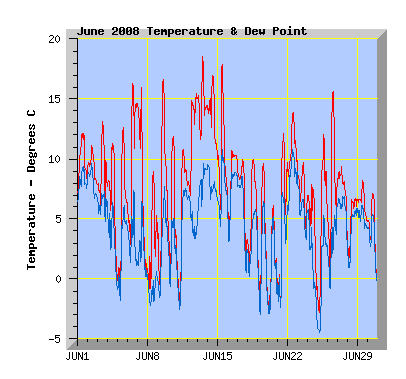
Temperature: My mean temperature for the month was 7.0C, this June was the 3rd warmest I've recorded. The highest temperature was 18.5C on the 13th. The lowest was -3.2C on the 25th. The maximum and minimum are typical of my previous June records. I recorded 13 days where temperatures were at or below 0C at some part of the day, which is the average for June in my records. June 2001 has my record of 20 days and June 2004 only 4 days where temperatures were at or below 0C at some part of the day My lowest June temperature to date is -6.2C on the 1st June 2002, the highest, 20.6C on 2 years, 30th June 2003 and 4th June 2004.
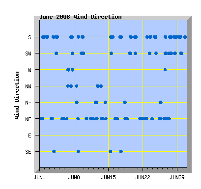
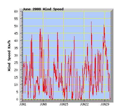
Wind: (Records from 2001) The monthly wind run of 3917km, this is the windiest June I have records for. The previous record was June 2003 with 3794km. The average June wind run is 3336km. The least windy June was 2006 with 2840km of wind run. Prevailing wind direction was north east recorded 38% of the month, south 34%, south west 13%, north 6%, north west 5%, south east and west 2% each. Maximum gust was 53km/h from the south on the 24th.
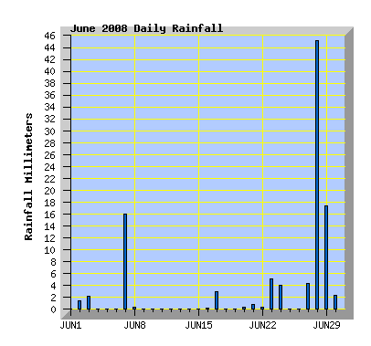
Rainfall: With 103.4mm, June was the third wettest I've recorded with 45.2mm or 43% of this falling in 1 day on the 28th. June had 9 rain days, my 9 year average is 10, the average rainfall for June at my station is 63mm from 9 years of records. The wettest June I've recorded was 2006 with 118.6mm, the driest is 2004 with 11.6mm, about half of that falling in 1 day.
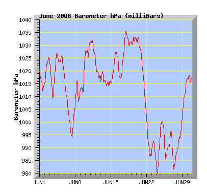
Barometer: (Records from 2006) The average pressure for this June was 1012.8 hPa which is close to my June average of 1013.4. Maximum pressure was 1035.4, the highest I've recorded for June. The lowest June pressure I've recorded was 971.5hPa in 2007.
| June 2008 Summary Temperature |
|
|---|---|
| Mean | 7.0 C |
| Mean Maximum | 12.0 C |
| Mean Minimum | 2.1 C |
| Maximum High | 18.5 C (13th) |
| Maximum Low | 11.5 C (13th) |
| Minimum High | 6.1 C (20th) |
| Minimum Low | -3.2 C (25th) |
| Wind Speed and Direction | |
| Maximum Gust | 53 km/h (24th) |
| Mean | 5.5 km/h |
| Wind Run | 3917 km |
| Max Daily Windrun | 318 km (29th) |
| Prevailing Direction | North East |
| Barometer | |
| Maximum | 1035.4 hPa (17th) |
| Minimum | 979.6 hPa (24th) |
| Mean | 1012.8 hPa |
| Max Daily Change | -23.2 hPa (21st) |
| Rainfall | |
| Days with Measured Rainfall (Greater than 0.2mm) | 14 |
| Max Daily Rainfall | 45.2 mm (28th) |
| Monthly Rainfall | 103.4 mm |
| Humidity | |
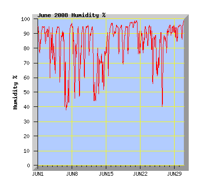
| Maximum | 99 % (Several Days) |
| Minimum | 37 % (6th) |
| June Daily Observations | ||||||||||||
|---|---|---|---|---|---|---|---|---|---|---|---|---|
| Temperature | Wind | Rainfall | Barometer | |||||||||
| Date | Min | Max | Mean | Mean (Km/h) | Gust (Km/h) | Run (km) | Prevailing Dir | 10 Minute Max (mm) | Total (mm) | Min (hPa) | Max (hPa) | Change (hPa) |
| 1 | 7.1 | 12.1 | 9.7 | 5.2 | 26 | 123 | North East | 0 | 0 | 1012.2 | 1020.5 | -8.3 |
| Mostly overcast with a few spots of rain during the day. Cloud breaking in the afternoon with some sunny intervals. A southerly change late afternoon with some light showers in the evening. | ||||||||||||
| 2 | 7.8 | 11.1 | 9.2 | 4.9 | 30 | 115 | South | 0.2 | 1.4 | 1015.0 | 1025.2 | +10.2 |
| Showers clearing in the afternoon with some sunny intervals. Cool southerly wind. | ||||||||||||
| 3 | 5.4 | 13.1 | 8.7 | 6.1 | 40 | 144 | North East | 1.0 | 2.2 | 1009.1 | 1024.3 | -15.2 |
| Mostly cloudy with NE winds. A change to southerly winds with showers in the evening. | ||||||||||||
| 4 | -0.2 | 11.3 | 6.6 | 6.7 | 44 | 157 | South | 0 | 0 | 1018.2 | 1027.1 | +8.9 |
| Morning cloud breaking and clearing by late afternoon and southerly winds easing. Frosty in the evening. | ||||||||||||
| 5 | -1.6 | 12.6 | 4.9 | 2.2 | 13 | 51 | North East | 0 | 0 | 1016.9 | 1026.2 | -9.3 |
| Frost. Clear and sunny with light Ne winds. | ||||||||||||
| 6 | 2.2 | 16.3 | 9.4 | 4.9 | 48 | 116 | West | 0 | 0 | 999.6 | 1016.7 | -17.1 |
| Variable mostly high cloud, NE winds turning nor'west in the evening. | ||||||||||||
| 7 | 0.3 | 16.0 | 7.9 | 10.2 | 48 | 243 | North West | 1.0 | 16.0 | 993.9 | 1006.1 | +12.2 |
| Gusty nor'westerly winds early in the morning. Days max temperature recorded at 10:50am. A cold southerly change with showers turning to rain and getting colder during the afternoon. Sleet followed by snow when the temperature reached about 2.5C about 4pm, other areas around Christchurch were reporting snow at different times. A dusting of snow settled here in the evening. NZ Herald report and photos of the snow as it affected Canterbury including a good fall in Timaru. | ||||||||||||
| 8 | -1.3 | 9.0 | 2.8 | 2.6 | 34 | 61 | South | 0.2 | 0.4 | 1006.7 | 1016.5 | +9.8 |
| Sunny with a little high cloud. Yesterdays snow melted in the afternoon. Cool with light winds during the day. | ||||||||||||
| 9 | -0.8 | 16.6 | 7.0 | 5.8 | 44 | 138 | South | 0 | 0 | 1011.5 | 1026.5 | +15.0 |
| Some cloud but mostly sunny. A gusty southerly change later in the afternoon. | ||||||||||||
| 10 | -0.3 | 11.9 | 4.9 | 1.1 | 15 | 26 | North East | 0 | 0 | 1025.2 | 1031.5 | +6.3 |
| Morning frost. Clear and sunny with light breezes. | ||||||||||||
| 11 | -2.0 | 10.8 | 4.8 | 4.2 | 28 | 100 | North East | 0 | 0 | 1024.7 | 1032.3 | -7.6 |
| Some cloud but mostly sunny with cool NE winds. | ||||||||||||
| 12 | 6.6 | 15.5 | 11.3 | 5.6 | 46 | 132 | North East | 0 | 0 | 1017.3 | 1024.2 | -6.9 |
| Mostly overcast with high cloud and north to NE winds. A change in the evening to gusty nor'westers with the maximum temperature for the day at 10pm. | ||||||||||||
| 13 | 11.5 | 18.5 | 14.2 | 5.3 | 41 | 125 | North East | 0 | 0 | 1015.5 | 1020.0 | -4.5 |
| Gusty nor'west winds early in the morning easing by dawn. Mostly cloudy with light NE winds during the day turning mild nor'west in the evening. | ||||||||||||
| 14 | 10.6 | 17.0 | 13.5 | 2.4 | 25 | 57 | North East | 0 | 0 | 1014.1 | 1016.3 | +2.2 |
| A nor'west arch of cloud for most of the day, light winds. | ||||||||||||
| 15 | 5.7 | 17.9 | 9.9 | 3.5 | 34 | 84 | South | 0 | 0 | 1014.9 | 1027.3 | +12.4 |
| Sunny with a few clouds in the afternoon. Southerly winds from midday. | ||||||||||||
| 16 | 3.3 | 10.7 | 8.1 | 4.9 | 30 | 115 | North East | 0.2 | 0.2 | 1017.0 | 1028.0 | -11.0 |
| Rainfall recorded was early morning fog which cleared by dawn. Cloud increasing during the morning and becoming overcast with low cloud. NE winds. | ||||||||||||
| 17 | 0.9 | 10.0 | 7.0 | 6.0 | 43 | 142 | South | 0.4 | 3.0 | 1016.9 | 1035.4 | +18.5 |
| Morning showers. Cloud clearing later in the afternoon. Southerly winds. | ||||||||||||
| 18 | 0.1 | 10.0 | 5.6 | 7.4 | 43 | 174 | North East | 0 | 0 | 1029.9 | 1035.4 | -5.5 |
| Sunny with some late afternoon cloud. NE winds. | ||||||||||||
| 19 | -2.5 | 9.6 | 2.8 | 2.8 | 21 | 65 | South | 0 | 0 | 1030.1 | 1033.2 | +3.1 |
| Clear and sunny with light southerly winds. Fog in the evening. | ||||||||||||
| 20 | -2.9 | 6.1 | 0.6 | 1.5 | 16 | 35 | South | 0.2 | 0.4 | 1026.5 | 1033.5 | -6.6 |
| Frost with fog that stayed all day. Cold with light southerly winds. Coldest maximum temperature for the year to date. | ||||||||||||
| 21 | -2.6 | 12.1 | 3.6 | 2.7 | 23 | 60 | North East | 0.4 | 0.8 | 1003.1 | 1026.3 | -23.2 |
| Morning mist and frost that was melted by a NE wind about 10am, the rainfall recorded is frost melt. Some high cloud but mostly sunny with NE winds easing in the afternoon. | ||||||||||||
| 22 | 7.8 | 13.9 | 10.6 | 7.8 | 29 | 185 | North East | 0.4 | 0.4 | 986.6 | 1002.8 | -16.2 |
| Light showers in the morning. Cloud breaking in the afternoon with sunny intervals. A southerly at night bringing a few showers. | ||||||||||||
| 23 | 2.9 | 9.9 | 7.1 | 7.9 | 38 | 186 | South | 0.8 | 5.2 | 982.6 | 993.0 | -10.4 |
| Early morning showers clearing by dawn and low cloud breaking in the afternoon. Cool southerly winds. | ||||||||||||
| 24 | -1.5 | 7.9 | 4.4 | 7.1 | 53 | 168 | South | 1.8 | 4.0 | 979.6 | 1000.1 | +20.5 |
| Broken cloud in the morning. A cold southerly front arrived about 10:45am bringing gusty winds, rain and hail for a short time but this had cleared by early afternoon. The hail was heavy in some areas of the city. Cloud clearing and wind easing in the evening with frost at night. | ||||||||||||
| 25 | -3.2 | 12.0 | 4.3 | 4.0 | 31 | 95 | North East | 0 | 0 | 985.2 | 1000.6 | -15.4 |
| High cloud with NE winds turning nor'west later in the afternoon. | ||||||||||||
| 26 | -0.1 | 15.6 | 6.9 | 3.7 | 34 | 88 | South | 0 | 0 | 987.8 | 997.1 | +9.3 |
| Broken cloud, mild about midday and early afternoon with westerly winds. Cooler later with southerly winds picking up. | ||||||||||||
| 27 | 3.9 | 9.4 | 7.8 | 8.6 | 33 | 203 | North East | 0.6 | 4.4 | 981.7 | 993.7 | -12.0 |
| Overcast with NE winds in the morning. A southerly change late morning with a period of rain easing by late afternoon. | ||||||||||||
| 28 | 1.3 | 6.7 | 4.8 | 13.2 | 51 | 312 | South | 1.8 | 45.2 | 988.7 | 1001.3 | +12.6 |
| Rain from morning with cold southerly winds strengthening from afternoon. | ||||||||||||
| 29 | 4.8 | 8.2 | 6.3 | 13.5 | 45 | 318 | South | 1.0 | 16.8 | 1001.8 | 1017.0 | +15.2 |
| Mostly overcast with showers and cold southerly winds. Cloud breaking a little in the afternoon. | ||||||||||||
| 30 | -0.8 | 7.1 | 3.9 | 3.5 | 27 | 83 | South West | 0.6 | 2.2 | 1015.5 | 1018.3 | -2.8 |
| Morning showers clearing in the afternoon. Cloud breaking in the evening and becoming frosty. | ||||||||||||