June Summary
One degree above average temperature, the warmest June since 2016, 57% of expected rainfall.
(June compared to my records from the past 10 years.)
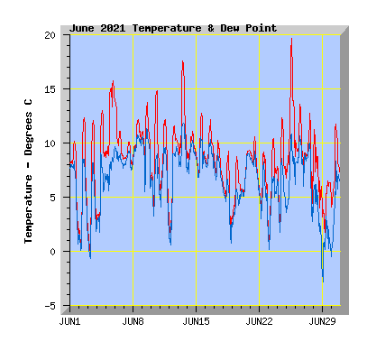
- This June was above my average temperature of 7.0c with 8.0C.
- The coldest temperature was -0.2C, my average June minimum is -2.8C.
- Just two air frosts (air temperature at or below 0) were recorded, my average is 8.
- The highest temperature was 19.9C, my average June maximum is 18.6C.
- Five days failed to reach or exceed 10C, my average is 8 days.
- Three days reached or exceeded 15C, my average is 4.
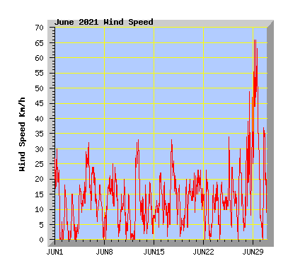
- Wind run was 104% of my average of 3041km with 3179km.
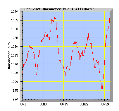
- The barometer recorded above average pressure for the month with 1017.2hPa. My average is 1014.4hPa.
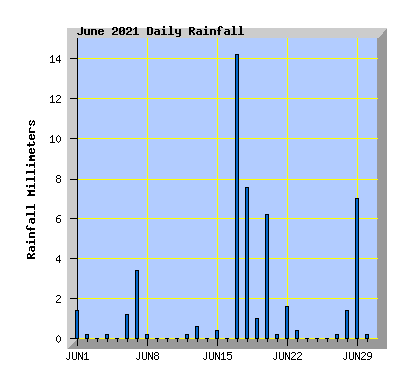
- Rainfall was 57% of the average expected total of 84mm with 48mm, the driest June since 2016 when 31mm fell.
- The wettest June in my records is 2013 with 233mm, the driest is 2004 with 11.6mm.
| June 2021 Summary Temperature | |
|---|---|
| Mean | 8.0 C |
| Mean Maximum | 12.1 C |
| Mean Minimum | 4.2 C |
| Maximum High | 19.7 C (25th) |
| Maximum Low | 8.4 C (13th) |
| Minimum High | 6.5 C (29th) |
| Minimum Low | -0.2 C (3rd) |
| Wind Speed and Direction | |
| Maximum Gust | 66 km/h (29th) |
| Mean | 4.6 km/h |
| Wind Run | 3179 km |
| Max Daily Windrun | 397 km (29th) |
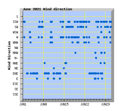
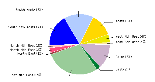
| Prevailing Direction | East North East |
| Barometer | |
| Maximum | 1038.3 hPa (30th) |
| Minimum | 993.8 hPa (28th) |
| Mean | 1017.2 hPa |
| Max Daily Change | +19.5 hPa (29th) |
| Rainfall | |
| Days with Measured Rainfall (0.2mm or more) |
20 |
| Max Daily Rainfall | 14.2 mm (17th) |
| Monthly Rainfall | 47.8 mm |
| Humidity | |
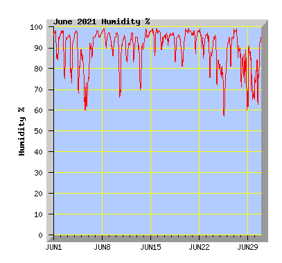
| Maximum | 99 % |
| Minimum | 57 % (25th) |
| June Daily Observations | ||||||||||||
|---|---|---|---|---|---|---|---|---|---|---|---|---|
| Temperature | Wind | Rainfall | Barometer | |||||||||
| Date | Min | Max | Mean | Mean (Km/h) | Gust (Km/h) | Run (km) | Prevailing Dir | 10 Minute Max (mm) | Total (mm) | Min (hPa) | Max (hPa) | Change (hPa) |
| 1 | 1.0 | 10.2 | 7.0 | 5.3 | 30 | 120 | South Sth West | 0.2 | 1.4 | 1005.0 | 1011.2 | +6.2 |
| Morning showers clearing and cloud breaking to sunny intervals in the afternoon with southerly winds dying away. Canterbury flooding: Rail network takes a battering; days before repairs can be made Ashburton Bridge closed for at least several days after 'significant damage' Flood protection work pays off as Christchurch homes stay dry |
||||||||||||
| 2 | 0.0 | 12.4 | 5.2 | 1.5 | 18 | 33 | East Nth East | 0.2 | 0.2 | 1010.2 | 1017.1 | +6.9 |
| Sunny with some thin high cloud and light winds tending NE Canterbury farmers stocktake of flood damage 'winter feed is all gone' Vital alpine link reopening soon as bridge crews tackle repairs from both ends Canterbury floods: Is climate change to blame for severe weather events? |
||||||||||||
| 3 | -0.2 | 12.1 | 4.7 | 1.3 | 15 | 30 | West | 0 | 0 | 1017.1 | 1020.9 | +3.8 |
| Sunny with light winds tending westerly. | ||||||||||||
| 4 | 1.9 | 13.0 | 7.1 | 2.6 | 18 | 60 | East Nth East | 0.2 | 0.2 | 1015.9 | 1019.7 | -3.8 |
| Morning mist and fog clearing leaving thin high cloud. Light winds tending NE. | ||||||||||||
| 5 | 7.2 | 15.8 | 12.1 | 7.9 | 32 | 179 | East Nth East | 0 | 0 | 1003.9 | 1015.5 | -11.6 |
| Overcast with high cloud and NE winds. Big rain, big pain, big cost - Canterbury's week of flooding devastation |
||||||||||||
| 6 | 8.4 | 14.1 | 10.4 | 6.9 | 24 | 157 | South West | 0.4 | 1.2 | 1007.1 | 1019.0 | +11.9 |
| Overcast with morning showers clearing by midday. Cool southerly wind. Maximum temperature recorded at 40 minutes past midnight. | ||||||||||||
| 7 | 7.5 | 10.1 | 8.8 | 3.2 | 18 | 72 | South West | 0.2 | 3.4 | 1019.2 | 1024.8 | +5.6 |
| Overcast with light rain and light winds. How much Canterbury flood damage was caused by climate change |
||||||||||||
| 8 | 8.0 | 12.2 | 10.2 | 3.7 | 21 | 85 | East Nth East | 0.2 | 0.2 | 1024.2 | 1028.0 | +3.8 |
| Overcast with some morning drizzle, light winds tending NE. May rainfall records broken in Lake Takapō/Tekapo |
||||||||||||
| 9 | 6.2 | 13.8 | 10.3 | 5.3 | 25 | 121 | East Nth East | 0 | 0 | 1024.9 | 1027.8 | -2.9 |
| Variable cloud with sunny intervals with a mostly light NE wind. | ||||||||||||
| 10 | 3.6 | 14.9 | 8.5 | 2.9 | 20 | 65 | West | 0 | 0 | 1023.7 | 1035.8 | |
| Morning fog clearing to a mostly sunny day. Light winds tending westerly. | ||||||||||||
| 11 | 3.3 | 12.2 | 8.0 | 1.0 | 15 | 23 | East Nth East | 0 | 0 | 1034.0 | 1036.7 | +2.7 |
| Cloudy with light winds tending NE. | ||||||||||||
| 12 | 1.0 | 11.6 | 7.0 | 5.8 | 33 | 134 | East Nth East | 0.2 | 0.2 | 1024.4 | 1036.9 | -12.5 |
| Morning mist and low cloud clearing, sunny intervals in the afternoon with cool a NE wind. | ||||||||||||
| 13 | 8.4 | 17.6 | 11.9 | 2.5 | 18 | 56 | East Nth East | 0.2 | 0.6 | 1011.5 | 1024.1 | -12.6 |
| Cloudy and mild with light breezes. Showers in the evening. | ||||||||||||
| 14 | 7.3 | 11.1 | 9.5 | 2.9 | 19 | 66 | South West | 0 | 0 | 1008.3 | 1011.7 | -3.4 |
| Morning fog and mist hanging around all day. Light winds tending southerly. Some of Canterbury's floods labelled a one-in-200-year event |
||||||||||||
| 15 | 6.8 | 12.8 | 9.0 | 3.5 | 22 | 79 | East Nth East | 0.2 | 0.4 | 1003.5 | 1008.3 | -4.8 |
| Thick fog clearing by late morning but remaining mostly cloudy with a few sunny intervals in the afternoon. Light NE winds turning southerly in the evening. | ||||||||||||
| 16 | 7.5 | 12.2 | 9.4 | 4.1 | 22 | 93 | South West | 0 | 0 | 1006.2 | 1009.1 | -2.9 |
| Cloudy with a few spots of drizzle and light southerly winds. | ||||||||||||
| 17 | 6.2 | 10.3 | 8.0 | 7.7 | 33 | 175 | West | 1.0 | 14.2 | 1006.8 | 1016.8 | +10.0 |
| Cloudy and cold with showers turning to rain in the evening. West to SW wind | ||||||||||||
| 18 | 0.9 | 9.3 | 5.3 | 3.5 | 21 | 79 | West | 0.8 | 7.2 | 1016.9 | 1023.4 | +6.5 |
| Cloudy with showers with light winds from the southwest. | ||||||||||||
| 19 | 2.7 | 8.8 | 5.6 | 2.4 | 20 | 55 | South Sth West | 0.2 | 1.0 | 1018.5 | 1022.8 | -4.3 |
| Cold and cloudy with light breezes tending southerly. Light rain at night. | ||||||||||||
| 20 | 5.3 | 9.4 | 7.2 | 6.1 | 22 | 139 | South West | 0.4 | 6.0 | 1012.2 | 1018.4 | -6.2 |
| Overcast with rain from late morning and light southerly winds. Tornadoes hit too fast to predict - meteorologist |
||||||||||||
| 21 | 5.8 | 10.6 | 8.4 | 7.5 | 23 | 170 | South Sth West | 0.2 | 0.2 | 1013.8 | 1017.9 | -4.1 |
| Occasional light drizzle and sunny intervals, light southerly wind. | ||||||||||||
| 22 | 2.4 | 9.2 | 6.0 | 2.8 | 23 | 64 | South Sth West | 1.2 | 1.6 | 1015.4 | 1022.6 | +6.9 |
| Cloud increasing with showers around midday. Light southerly winds. | ||||||||||||
| 23 | 0.5 | 10.5 | 5.8 | 2.7 | 19 | 60 | East Nth East | 0.4 | 0.4 | 1022.2 | 1027.8 | +5.6 |
| Mostly cloudy with a morning shower. Brighter in the afternoon with light variable southerly winds turning NE. Snow in Christchurch possible next week, despite NZ heading for warmest June on record |
||||||||||||
| 24 | 2.1 | 12.4 | 7.1 | 3.0 | 19 | 68 | East Nth East | 0 | 0 | 1015.6 | 1023.1 | -7.5 |
| Variable cloud with some sunny intervals. Light NE wind. | ||||||||||||
| 25 | 5.6 | 19.7 | 11.4 | 3.8 | 34 | 86 | East Nth East | 0 | 0 | 1007.4 | 1015.9 | -8.5 |
| Cloudy with some sunny intervals. Mild in the afternoon with northerly winds. Forecast snow confined to Banks Peninsula, unlikely to reach Christchurch |
||||||||||||
| 26 | 5.7 | 13.6 | 9.6 | 4.5 | 24 | 103 | South West | 0 | 0 | 1008.3 | 1013.0 | +4.7 |
| Cloudy morning with light showers. Cloud breaking for a while in the afternoon before low cloud returned. Variable winds tending southerly. | ||||||||||||
| 27 | 3.8 | 12.8 | 8.5 | 4.2 | 30 | 95 | East Nth East | 0.2 | 0.2 | 997.1 | 1011.1 | -14.0 |
| Fog clearing after midday with sunny intervals in the afternoon. Variable winds tending NE. | ||||||||||||
| 28 | 2.6 | 11.3 | 6.6 | 8.4 | 49 | 193 | South Sth West | 0.6 | 1.4 | 993.8 | 1009.7 | +15.9 |
| Cold southerly winds arrived in the morning. Showers with hail from midday. Maximum temperature recorded at 3:30am, minimum temperature recorded at 1:30pm during a hail shower. Study finds Lyttelton sea levels rising faster than thought |
||||||||||||
| 29 | 1.1 | 6.5 | 4.3 | 17.3 | 66 | 397 | South West | 0.6 | 7.0 | 1009.9 | 1029.4 | +19.5 |
| Showers with hail and some snow flurries and a cold southerly wind. Wild weather in photos and video: Snow dump and winds across Aotearoa |
||||||||||||
| 30 | 3.8 | 11.8 | 7.3 | 4.8 | 37 | 110 | South Sth West | 0.2 | 0.2 | 1029.0 | 1038.3 | +9.3 |
| Cloud breaking with sunny intervals in the afternoon with southerly winds. | ||||||||||||