April Summary
Above average temperature and a new maximum temperature record for my station, 32% of expected rainfall, least windy of any April in my records.
(April compared to my records from the past 10 years.)
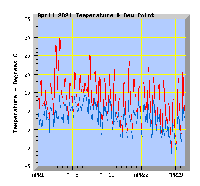
- This April above my average temperature of 12.3c with 12.7C.
- The coldest temperature was -0.7C, colder than my average April minimum of 1.3C.
- One air frost (air temperature at or below 0) was recorded. In the past 10 years, only April 2011 has recorded an airfrost with -1.7C.
- The highest temperature was 30.0C, a new April maximum for my station. The previous record was 29.0C in 2017. My average April maximum is 26.6C.
- Twenty seven days reached or exceeded 15C, my average is 23 days.
- Twelve days reached or exceeded 20C, my average is 8 days.
- Three days reached or exceeded 25C, my average is 2 days.
- One day reached or exceeded 30C for the first time in my records.
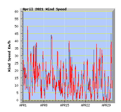
- Wind run was 73% of my average of 3617km with 2859km, the least windy April in my records.
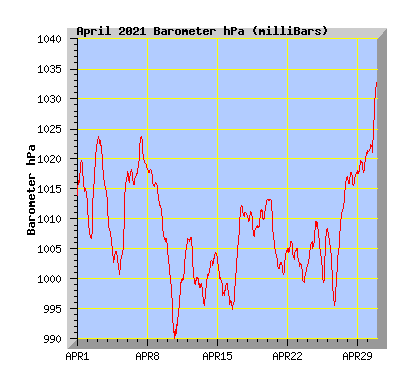
- The barometer recorded below average pressure for the month with 1008.5hPa. My average is 1015.0hPa.
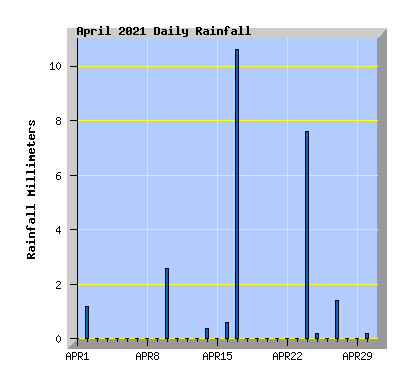
- Rainfall was just 32% of the average expected total of 77mm with 24.8mm,
- This is the driest April in the past 10 years is 2020 with 7.8mm. In all my April records its 2001 with 4.5mm.
- The wettest April in the past 10 years and in all my April records is 2015 with 201.5mm.
| April 2021 Summary Temperature | |
|---|---|
| Mean | 12.7 C |
| Mean Maximum | 19.6 C |
| Mean Minimum | 6.9 C |
| Maximum High | 30.0 C (5th) |
| Maximum Low | 14.6 C (10th) |
| Minimum High | 12.2 C (27th) |
| Minimum Low | -0.7 C (28th) |
| Wind Speed and Direction | |
| Maximum Gust | 50 km/h (2nd) |
| Mean | 4.2 km/h |
| Wind Run | 2859 km |
| Max Daily Windrun | 231 km (10th) |
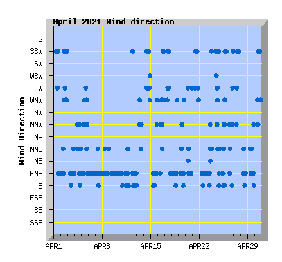
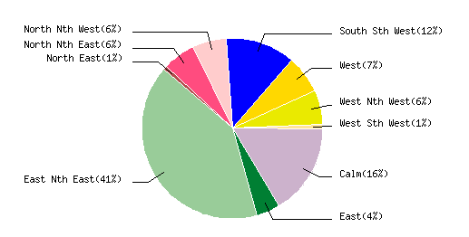
| Prevailing Direction | East North East |
| Barometer | |
| Maximum | 1033.0 hPa (30th) |
| Minimum | 990.0 hPa (10th) |
| Mean | 1008.5 hPa |
| Max Daily Change | +16.5 hPa (5th) |
| Rainfall | |
| Days with Measured Rainfall (0.2mm or more) |
9 |
| Max Daily Rainfall | 10.6 mm (17th) |
| Monthly Rainfall | 24.8 mm |
| Humidity | |
| Maximum | 95 % (21st) |
| Minimum | 28 % (5th) |
| April Daily Observations | ||||||||||||
|---|---|---|---|---|---|---|---|---|---|---|---|---|
| Temperature | Wind | Rainfall | Barometer | |||||||||
| Date | Min | Max | Mean | Mean (Km/h) | Gust (Km/h) | Run (km) | Prevailing Dir | 10 Minute Max (mm) | Total (mm) | Min (hPa) | Max (hPa) | Change (hPa) |
| 1 | 10.1 | 18.4 | 13.9 | 6.4 | 30 | 146 | South Sth West | 0 | 0 | 1013.1 | 1019.8 | -6.7 |
| Early light showers clearing by dawn. Morning cloud breaking to a sunny afternoon. Southerly winds turning NE from late afternoon. | ||||||||||||
| 2 | 10.0 | 16.0 | 12.0 | 5.7 | 50 | 131 | East Nth East | 0.4 | 1.2 | 1006.5 | 1022.8 | +16.3 |
| Overcast with showers from midday with a southerly change. | ||||||||||||
| 3 | 4.7 | 17.5 | 12.0 | 5.1 | 33 | 116 | East Nth East | 0 | 0 | 1013.5 | 1023.8 | -10.3 |
| Sunny with a NE in the afternoon. | ||||||||||||
| 4 | 8.5 | 28.3 | 18.5 | 4.9 | 37 | 117 | East Nth East | 0 | 0 | 1002.8 | 1013.2 | -10.4 |
| Sunny and warm with north to NW winds from mid morning. Timaru hotter than Rarotonga as nor'west winds drive up temperatures across the south Marlborough nearly records its lowest March rainfall in 92 years |
||||||||||||
| 5 | 13.9 | 30.0 | 21.1 | 7.5 | 39 | 171 | West Nth West | 0 | 0 | 1000.7 | 1017,2 | +16.5 |
| Sunny and very warm for the time of year. A new April record high temperature for my station, previous record was 29C on the 2nd April 2017. Christchurch notches up driest March in 12 years (In my records I have to go back to 2001 for a drier March - 20 years!) |
||||||||||||
| 6 | 11.4 | 19.2 | 14.7 | 6.2 | 25 | 142 | East Nth East | 0 | 0 | 1015.7 | 1018.3 | -2.6 |
| Sunny with light NE winds. | ||||||||||||
| 7 | 7.5 | 18.1 | 13.0 | 5.7 | 33 | 131 | East Nth East | 0 | 0 | 1017.4 | 1023.7 | +6.3 |
| Morning cloud breaking to a sunny afternoon, cloud returning in the evening. NE wind. | ||||||||||||
| 8 | 9.1 | 20.8 | 14.3 | 3.7 | 26 | 84 | East Nth East | 0 | 0 | 1015.4 | 1018.3 | -2.9 |
| Some morning mist. Clear and sunny with light winds. | ||||||||||||
| 9 | 10.6 | 19.8 | 15.0 | 4.4 | 19 | 101 | East Nth East | 0 | 0 | 1005.8 | 1015.3 | -9.5 |
| Some high cloud but a mostly sunny day. becoming overcast later in the afternoon. Light NE winds. Parts of NZ dangerously dry with no immediate end in sight 1968: The Wahine storm - Damage in Christchurch |
||||||||||||
| 10 | 14.6 | 18.2 | 16.0 | 10.1 | 44 | 231 | East Nth East | 0.4 | 2.6 | 990.0 | 1005.7 | -15.7 |
| Overcast with morning showers clearing. NE wind freshening from late morning but dying away in the evening. | ||||||||||||
| 11 | 11.8 | 25.3 | 17.8 | 2.1 | 22 | 47 | East Nth East | 0 | 0 | 992.3 | 1005.8 | +13.5 |
| High cloud breaking to a sunny and mild afternoon with light breezes tending NE. | ||||||||||||
| 12 | 10.0 | 20.9 | 15.3 | 5.4 | 33 | 124 | East Nth East | 0 | 0 | 999.0 | 1007.3 | -8.3 |
| Morning cloud with a few spots of rain. Cloud breaking to a mostly sunny afternoon with NE wind. | ||||||||||||
| 13 | 6.7 | 22.1 | 13.2 | 1.6 | 27 | 35 | North Nth West | 0 | 0 | 995.6 | 1000.5 | -4.9 |
| Cloud increasing with a few spots of rain before midday. Light winds tending nor'west Record-breaking dry conditions biting North Canterbury, Banks Peninsula farmers |
||||||||||||
| 14 | 7.1 | 19.0 | 12.5 | 4.4 | 26 | 99 | South Sth West | 0.2 | 0.4 | 1000.0 | 1004.4 | +4.4 |
| Light showers in the morning clearing and cloud breaking. Southerly wind. | ||||||||||||
| 15 | 8.7 | 20.0 | 12.7 | 3.5 | 28 | 80 | East Nth East | 0 | 0 | 996.9 | 1003.4 | -6.5 |
| Partly cloudy with an afternoon shower. Mostly light NE winds. | ||||||||||||
| 16 | 6.2 | 22.8 | 13.3 | 5.3 | 40 | 122 | East Nth East | 0.2 | 0.6 | 994.7 | 1003.8 | +9.1 |
| Light easterly winds turning warm nor'west from late morning with increasing cloud. A southerly change with showers in the evening. | ||||||||||||
| 17 | 5.0 | 13.4 | 9.3 | 3.3 | 29 | 75 | South Sth West | 1.0 | 10.6 | 1004.1 | 1012.4 | +8.3 |
| Morning showers clearing and cloud breaking to a sunny afternoon with light southerly winds. Wettest day of the year to date. | ||||||||||||
| 18 | 3.6 | 18.0 | 10.6 | 2.9 | 24 | 65 | East Nth East | 0 | 0 | 1007.1 | 1011.4 | -4.3 |
| Sunny morning, high cloud increasing in the afternoon, light NE winds. | ||||||||||||
| 19 | 4.5 | 23.4 | 12.6 | 1.5 | 19 | 34 | East Nth East | 0 | 0 | 1008.5 | 1013.2 | +4.7 |
| Sunny and mild with light breezes tending NE. | ||||||||||||
| 20 | 4.7 | 19.0 | 12.1 | 1.8 | 20 | 41 | East Nth East | 0 | 0 | 1003.1 | 1013.5 | -10.4 |
| Increasing high cloud, light winds tending NE. | ||||||||||||
| 21 | 5.8 | 16.7 | 11.8 | 4.6 | 26 | 105 | South Sth West | 0 | 0 | 1000.7 | 1004.7 | +4.0 |
| Sunny with light winds tending southerly from late morning. | ||||||||||||
| 22 | 3.9 | 17.7 | 10.6 | 2.8 | 28 | 64 | East Nth East | 0 | 0 | 1003.1 | 1006.6 | -3,5 |
| Sunny with NE winds from late morning. | ||||||||||||
| 23 | 7.9 | 22.0 | 14.0 | 1.5 | 15 | 35 | East Nth East | 0 | 0 | 999.2 | 1004.8 | -5.6 |
| Sunny with some high cloud, mild with light north to NE winds. | ||||||||||||
| 24 | 5.6 | 20.0 | 11.5 | 3.5 | 34 | 80 | South Sth West | 2.2 | 7.6 | 1002.0 | 1010.2 | +8.2 |
| Sunny with some high cloud. Overcast later in the afternoon. An evening thunder storm for about 30 minutes from 8pm. | ||||||||||||
| 25 | 4.8 | 17.2 | 10.5 | 3.3 | 38 | 74 | East Nth East | 0.2 | 0.2 | 999.4 | 1009.2 | -9.8 |
| Variable cloud with light breezes tending NE. A southerly change in the evening with late showers. | ||||||||||||
| 26 | 3.6 | 18.2 | 9.9 | 4.9 | 35 | 111 | East Nth East | 0 | 0 | 995.6 | 1008.6 | -13.0 |
| Sunny morning, cloud increasing in the afternoon with NE wind turning nor'west. A southerly change later in the evening. | ||||||||||||
| 27 | 3.1 | 12.2 | 8.0 | 5.3 | 34 | 121 | South Sth West | 0.4 | 1.4 | 1001.8 | 1017.1 | +15.3 |
| Morning shower clearing and cloud breaking to a sunny afternoon with a cool southerly wind. | ||||||||||||
| 28 | -0.7 | 13.3 | 6.3 | 1.7 | 20 | 37 | East Nth East | 0 | 0 | 1015.5 | 1018.0 | -2.5 |
| First morning below 0 since the 30th Sept 2020. Sunny with light winds | ||||||||||||
| 29 | 0.4 | 19.1 | 8.7 | 1.4 | 16 | 32 | East Nth East | 0 | 0 | 1017,5 | 1021.2 | +3.7 |
| Clear and sunny, mild from late morning. Light winds tending NE. Hydro power: More dry weather may mean blackouts, switch to coal-generated The big melt: New Zealand's glaciers losing 1.5m of thickness each year |
||||||||||||
| 30 | 3.3 | 21.7 | 10.1 | 4.2 | 45 | 94 | South Sth West | 0.2 | 0.2 | 1021.0 | 1033.0 | +12.0 |
| Mild northerly winds. Cloud increasing in the afternoon with a cooler southerly change arriving about 1pm. Warm, dry winter on the way for New Zealand |
||||||||||||