November Summary
Average temperature, 109% of expected rainfall, windiest November since 2015.
(November compared to my records from the past 10 years.)
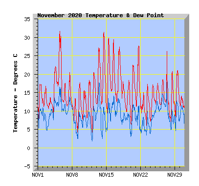
- This November equalled my average temperature of 14.2C
- The coldest temperature was 3.3C, a little higher than my average minimum of 2.2C
- No days recorded an air frost (0c or below), my average is 0.
- No days failed to reach 10C, my average is 0.
- Twenty seven days reached or exceeded 15C, my average is 28.
- Fourteen days reached or exceeded 20C, my average is 16.
- Eight days reached or exceeded 25C, my average is 6.
- Two days reached or exceeded 30C, my average is 1.
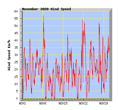
- Wind run was 102% of my average of 4974km with 5077km.It was the windiest November since 2015.
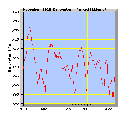
- The barometer recorded above average pressure for the month with 1011.0hPa. My average is 1010.0hPa.
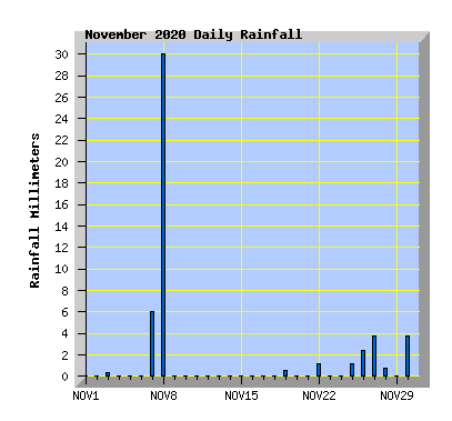
- Rainfall was 109% of the average expected total of 46mm with 50.2mm,
- The driest November was 2017 which had just 0.5mm.
- The wettest November in the past 10 years is 2018 with 88.5mm.
- 2020 is now 278mm below the expected average rainfall total as at 30 November.
| November 2020 Summary Temperature | |
|---|---|
| Mean | 14.2 C |
| Mean Maximum | 20.9 C |
| Mean Minimum | 9.0 C |
| Maximum High | 31.7 C (5th) |
| Maximum Low | 13.9 C (16th) |
| Minimum High | 13.5 C (8th) |
| Minimum Low | 3.3 C (9th) |
| Wind Speed and Direction | |
| Maximum Gust | 57 km/h (8th) |
| Mean | 7.4 km/h |
| Wind Run | 5077 km |
| Max Daily Windrun | 379 km (22nd) |
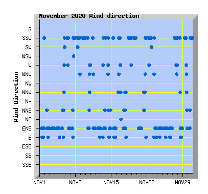
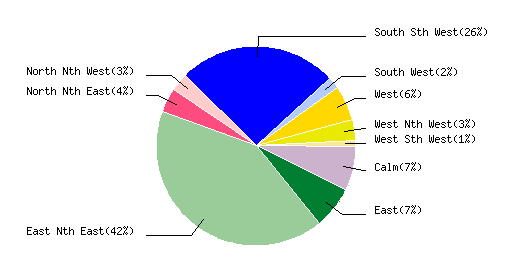
| Prevailing Direction | East North East |
| Barometer | |
| Maximum | 1031.9 hPa (2nd) |
| Minimum | 991.9 hPa (30th) |
| Mean | 1011.0 hPa |
| Max Daily Change | +20.0 hPa (8th) |
| Rainfall | |
| Days with Measured Rainfall (0.2mm or more) |
10 |
| Max Daily Rainfall | 29.6 mm (8th) |
| Monthly Rainfall | 50.2 mm |
| Humidity | |
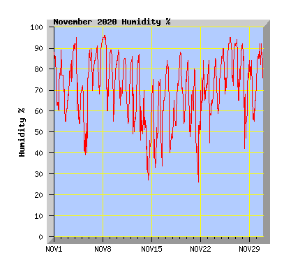
| Maximum | 96 % (8th) |
| Minimum | 26 % (14th) |
| November Daily Observations | ||||||||||||
|---|---|---|---|---|---|---|---|---|---|---|---|---|
| Temperature | Wind | Rainfall | Barometer | |||||||||
| Date | Min | Max | Mean | Mean (Km/h) | Gust (Km/h) | Run (km) | Prevailing Dir | 10 Minute Max (mm) | Total (mm) | Min (hPa) | Max (hPa) | Change (hPa) |
| 1 | 7.0 | 17.3 | 13.4 | 8.1 | 35 | 185 | East Nth East | 0 | 0 | 1009.3 | 1019.2 | +9.9 |
| Cloud morning and later in the afternoon, sunny for much of the day with NE winds. | ||||||||||||
| 2 | 11.1 | 16.8 | 13.1 | 7.0 | 28 | 160 | East Nth East | 0 | 0 | 1019.2 | 1031.9 | +12.7 |
| Cloudy with mostly light NE wind. | ||||||||||||
| 3 | 10.5 | 13.7 | 11.7 | 9.2 | 41 | 210 | East Nth East | 0.2 | 0.4 | 1021.7 | 1031.8 | -10.1 |
| Cloudy with light rain from late morning then a few light showers later in the afternoon. NE wind. | ||||||||||||
| 4 | 8.1 | 22.1 | 16.3 | 5.8 | 31 | 134 | East Nth East | 0 | 0 | 1011.9 | 1021.9 | -10.0 |
| Morning mist or fog clearing to a sunny and mild day with NE wind. | ||||||||||||
| 5 | 13.2 | 31.7 | 21.8 | 7.3 | 33 | 165 | East Nth East | 0 | 0 | 999.7 | 1011.5 | -11.8 |
| Variable high cloud with warm NNE winds | ||||||||||||
| 6 | 11.2 | 17.6 | 13.1 | 9.9 | 34 | 226 | South Sth West | 0 | 0 | 1002.9 | 1008.8 | +5.9 |
| Cloudy with morning showers and a few spots of rain in the afternoon. Southerly winds turning NE in the evening. | ||||||||||||
| 7 | 11.1 | 20.5 | 14.1 | 6.5 | 28 | 148 | East Nth East | 0.4 | 6.0 | 999.1 | 1007.1 | -8.0 |
| Cloudy with NE winds turning southerly mid afternoon with a few spots of rain. Light steady rain from evening. | ||||||||||||
| 8 | 5.7 | 13.5 | 9.7 | 13.5 | 57 | 309 | South Sth West | 1.0 | 29.6 | 996.3 | 1016.3 | +20.0 |
| Morning rain and strong southerly winds. Rain clearing and wind easing in the afternoon. The wettest day to date of 2020. Previous total was 29 June with 27.4mm | ||||||||||||
| 9 | 3.3 | 17.7 | 10.3 | 4.5 | 31 | 102 | South Sth West | 0 | 0 | 1016.3 | 1023.0 | +6.7 |
| Overcast with mostly light southerly wind. | ||||||||||||
| 10 | 7.1 | 15.6 | 11.2 | 2.5 | 17 | 56 | South Sth West | 0 | 0 | 1019.0 | 1023.1 | -4.1 |
| Cloudy with light southerly winds turning NE in the afternoon. Napier flooding: Deluge the second wettest day on record in 150 years |
||||||||||||
| 11 | 6.3 | 18.4 | 12.0 | 3.2 | 21 | 73 | East Nth East | 0 | 0 | 1014.4 | 1019.1 | -4.7 |
| Cloud breaking to a sunny afternoon. Light southerly winds turning NE in the afternoon. | ||||||||||||
| 12 | 3.7 | 20.5 | 12.7 | 5.7 | 28 | 130 | East Nth East | 0 | 0 | 1015.1 | 1018.5 | +3.4 |
| Some cloud but mostly sunny and mild with NE wind. | ||||||||||||
| 13 | 11.9 | 27.2 | 18.4 | 6.3 | 24 | 142 | East Nth East | 0 | 0 | 1008.8 | 1017.5 | -8.7 |
| Some cloud but mostly sunny and warm with winds tending NE. | ||||||||||||
| 14 | 11.2 | 31.5 | 19.1 | 4.9 | 31 | 111 | South Sth West | 0 | 0 | 1008.0 | 1010.9 | +2.9 |
| Sunny and warm with variable winds tending southerly. | ||||||||||||
| 15 | 8.9 | 29.9 | 18.5 | 5.2 | 29 | 119 | East Nth East | 0 | 0 | 1008.1 | 1011.1 | -3.0 |
| Sunny and warm with a light southerly wind turning NE in the afternoon. | ||||||||||||
| 16 | 13.9 | 29.5 | 18.9 | 8.6 | 44 | 196 | East Nth East | 0 | 0 | 1003.4 | 1011.1 | +7.7 |
| Sunny and warm morning with northerly winds. A southerly change after midday but remaining sunny and mild. Running hot: Some coastal areas are now in a 'marine heatwave' Christchurch nears a heatwave as 'mixed bag' of weather blankets the country |
||||||||||||
| 17 | 12.3 | 27.5 | 19.0 | 9.3 | 35 | 212 | East Nth East | 0 | 0 | 995.7 | 1010.7 | -15.0 |
| Cloudy with NE winds turning warm nor'west after midday. This is the 5th consecutive day with temperatures 5 or more degrees above the average maximum temperature recorded in November (19C) making the past 5 days an official heatwave according to Metservice. Christchurch enters a heatwave after temperaturess hit 25C Timaru's hailstorm cost reaches record $170m mark |
||||||||||||
| 18 | 10.6 | 19.3 | 14.8 | 4.2 | 25 | 96 | South Sth West | 0 | 0 | 997.2 | 1015.3 | +18.1 |
| Overcast with westerly winds turning light southerly from mid morning. A few light showers from afternoon. Maximum temperature recorded at midnight. | ||||||||||||
| 19 | 7.6 | 18.4 | 12.6 | 6.0 | 27 | 137 | South Sth West | 0.4 | 0.6 | 1015.6 | 1020.7 | +5.1 |
| Cloudy morning with light showers. Cloud breaking to a mostly sunny afternoon. | ||||||||||||
| 20 | 6.0 | 22.5 | 14.6 | 4.6 | 22 | 105 | East Nth East | 0 | 0 | 1012.6 | 1020.4 | -7.8 |
| Variable high cloud during the day. Overcast later in the afternoon with a few spots of rain. NE wind. | ||||||||||||
| 21 | 10.6 | 27.8 | 17.3 | 8.4 | 54 | 191 | South Sth West | 0 | 0 | 997.2 | 1012.3 | -15.1 |
| Variable high cloud but mostly sunny during the day with warm north to nor'west winds. Cooler southerly change arriving about 5pm but remaining dry. | ||||||||||||
| 22 | 9.0 | 15,1 | 10.8 | 16.5 | 53 | 379 | South Sth West | 0.2 | 1.2 | 1006.5 | 1018.3 | +11.8 |
| Morning showers with a cool southerly wind. Cloud breaking in the afternoon. | ||||||||||||
| 23 | 5.6 | 17.3 | 11.0 | 2.7 | 19 | 62 | East Nth East | 0 | 0 | 1012.9 | 1018.0 | -5.1 |
| Overcast with light variable breezes turning NE in the afternoon. | ||||||||||||
| 24 | 6.6 | 17.2 | 12.4 | 9.6 | 40 | 219 | East Nth East | 0 | 0 | 1009.5 | 1013.2 | -3.7 |
| Cloudy with NE wind freshening in the afternoon. Dry summer expected for parts of Canterbury |
||||||||||||
| 25 | 11.7 | 17.6 | 14.0 | 9.4 | 36 | 214 | East Nth East | 0.2 | 1.2 | 1011.2 | 1013.9 | +2.7 |
| Morning shower then a few spots of rain at times during the day, drizzle at night. NE wind. | ||||||||||||
| 26 | 11.6 | 18.6 | 14.2 | 7.7 | 27 | 175 | East Nth East | 0.2 | 2.2 | 1000,5 | 1013,4 | -12.9 |
| Morning drizzle. Cloud breaking in the afternoon with sunny intervals but low cloud returning in the evening with some drizzle. NE wind. | ||||||||||||
| 27 | 8.4 | 26.2 | 13.4 | 9.7 | 52 | 221 | East Nth East | 1.4 | 3.8 | 996.2 | 1012.9 | +16.7 |
| Fog lifting to a sunny morning. A southerly change arriving late morning with afternoon and evening showers. Despite wet week for many, some areas still drying out and expected to get drier |
||||||||||||
| 28 | 6.7 | 20.8 | 12.3 | 7.0 | 43 | 161 | East Nth East | 0.2 | 0.6 | 998.0 | 1013.8 | -15.8 |
| Early showers clearing before dawn to a mostly sunny morning. NE winds freshening in the afternoon and becoming overcast with high cloud. | ||||||||||||
| 29 | 7.2 | 21.1 | 14.5 | 6.8 | 36 | 155 | South Sth West | 0 | 0 | 994.1 | 1002.9 | +8.8 |
| Cloud morning and evening but mostly sunny during the day. Southerly winds picking up in the afternoon. New analysis reveals New Zealand's 150-year climate transformation |
||||||||||||
| 30 | 10.4 | 14.1 | 12.1 | 11.9 | 43 | 271 | East Nth East | 0.4 | 3.8 | 991.9 | 1009.1 | +17.2 |
| Cloudy with showers. A southerly change around midday. | ||||||||||||