| May | Min. Temp | Max. Temp | Avg. Temp | Rain | Prevailing Wind Dir. | Avg. Wind Speed | Max Gust | Wind Run | Casual Observations |
| 1 |
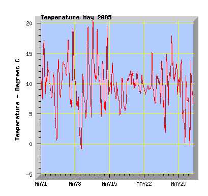
6.4 |
17.1 |
11.2 |
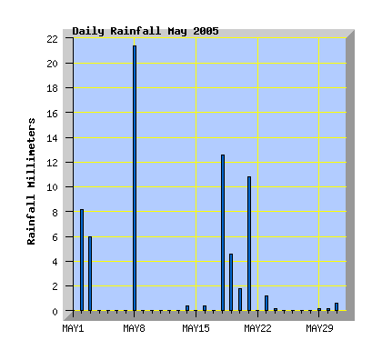
0 |
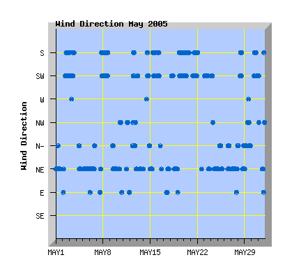
North East |
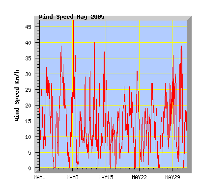
4.7 |
25 |
123 |
Clear and sunny with NE wind. |
| 2 |
8.7 |
13.6 |
10.5 |
9.4 |
South |
8.1 |
32 |
201 |
Mostly cloudy. Southerly change in the morning with rain by late afternoon. |
| 3 |
3.8 |
11.8 |
8.3 |
4.8 |
South West |
6.1 |
27 |
155 |
Morning showers clearing in the afternoon with cloud breaking and clearing in the evening. |
| 4 |
0.2 |
14.0 |
7.0 |
0 |
North East |
1.7 |
18 |
47 |
Ground frost, clear and sunny with light NE breeze. |
| 5 |
7.4 |
13.6 |
11.4 |
0 |
North East |
10.2 |
39 |
254 |
Low cloud and NE wind. |
| 6 |
6.2 |
17.2 |
12.3 |
0 |
North East |
6.4 |
33 |
162 |
Some high cloud but mostly sunny with NE winds. |
| 7 |
5.6 |
19.2 |
11.3 |
0 |
South West |
3.3 |
25 |
85 |
High cloud with warm northerlies. A southerly change in the evening. |
| 8 |
1.0 |
10.2 |
6.0 |
21.4 |
South West |
8.8 |
47 |
216 |
Cold with southerly winds and showers, some with hail. Cloud clearing in the evening. |
| 9 |
-1.3 |
11.6 |
4.8 |
0 |
North East |
2.8 |
18 |
74 |
First air frost of the year. Some high cloud but sunny with light winds. |
| 10 |
3.4 |
19.4 |
10.4 |
0 |
North West |
2.5 |
29 |
69 |
Warm northerly winds in the afternoon, high cloud increasing. |
| 11 |
4.1 |
20.3 |
11.7 |
0 |
North West |
2.2 |
31 |
60 |
Sunny with warm nor'west winds. Some cloud in the afternoon. |
| 12 |
9.7 |
19.0 |
11.9 |
0 |
South |
4.8 |
40 |
124 |
Warm Nor'west winds in the morning followed by a cooler gusty southerly change with increasing cloud. Winds easing in the evening and turning northerly. |
| 13 |
4.3 |
13.7 |
8.7 |
0 |
North East |
3.2 |
27 |
84 |
Morning cloud clearing to a sunny day with cool NE winds. |
| 14 |
4.5 |
19.5 |
9.7 |
0.4 |
South West |
5.1 |
37 |
133 |
Warm nor'west breeze in the morning followed by cooler southerly winds but remaining sunny. Evening cloud with showers. |
| 15 |
7.6 |
13.4 |
10.1 |
0 |
South |
4.2 |
28 |
110 |
Cloudy but some breaks about midday. Cool southerly breeze. |
| 16 |
6.6 |
10.2 |
7.9 |
0.4 |
South West |
2.4 |
16 |
65 |
Cloudy and cool with light showers during the day. Variable winds, mostly southerly. |
| 17 |
4.4 |
10.9 |
7.1 |
0 |
East |
1.7 |
19 |
47 |
Cloudy with some breaks. Cool with east to northeast winds. |
| 18 |
5.3 |
11.3 |
8.4 |
14.4 |
North East |
3.8 |
26 |
101 |
Overcast with light rain. Light southerly winds turning NE in the afternoon with warmer temperatures. |
| 19 |
9.0 |
12.1 |
10.8 |
3.0 |
South West |
4.5 |
26 |
119 |
Dull with low cloud with morning drizzle and evening mist. |
| 20 |
8.9 |
12.0 |
10.1 |
1.6 |
South |
4.8 |
24 |
124 |
Morning drizzle clearing but remaining overcast and dull. |
| 21 |
8.4 |
11.4 |
9.4 |
10.8 |
South West |
7.5 |
31 |
185 |
Morning rain clearing around midday with cloud breaking. Becoming overcast again late afternoon. Cool southerly winds. |
| 22 |
8.1 |
9.6 |
8.9 |
0 |
South |
1.2 |
16 |
37 |
Low cloud and mist with occasional drizzle. |
| 23 |
8.4 |
15.2 |
10.1 |
1.2 |
South West |
4.1 |
19 |
108 |
Morning showers and cloud clearing to a sunny afternoon. Sea fog rolling back in late afternoon. |
| 24 |
5.8 |
11.6 |
8.9 |
0.2 |
North East |
5.8 |
27 |
148 |
Morning low cloud and fog clearing by midday then sunny with NE wind. |
| 25 |
5.0 |
13.8 |
9.4 |
0 |
North East |
3.3 |
19 |
86 |
Morning fog clearng to a sunny afternoon. Light winds. |
| 26 |
1.5 |
14.9 |
7.5 |
0 |
North East |
1.5 |
16 |
40 |
Ground frost and some fog clearing to a sunny day with light breezes. |
| 27 |
6.2 |
17.9 |
12.5 |
0 |
North East |
5.9 |
27 |
151 |
Warmer with variable, mostly high cloud. NE winds. |
| 28 |
7.9 |
13.3 |
10.7 |
0 |
North East |
5.4 |
32 |
137 |
Southerly winds in the morning turning cooler NE in afternoon. Mostly sunny. |
| 29 |
3.4 |
13.9 |
9.3 |
0.2 |
North West |
5.5 |
36 |
140 |
Sunny with north to nor'west winds. |
| 30 |
-0.8 |
11.3 |
5.4 |
0.2 |
South West |
6.9 |
39 |
171 |
Morning frost. Cloud increasing with afternoon and evening showers, some with hail. Cool southerly winds. |
| 31 |
-1.0 |
13.8 |
6.3 |
0.8 |
North East |
3.8 |
31 |
99 |
Frost then a sunny morning. High cloud increasing in the afternoon. An evening southerly change with showers. |