May Summary
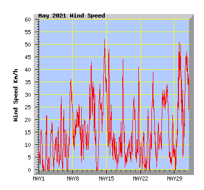
Near average temperature and a new May maximum temperature record for my station, 259% of expected rainfall and the windiest May since 2010.
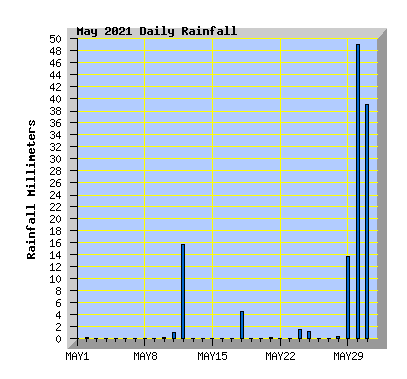
With 101.6mm of rain falling from the 29th to the 31st, it made this the wettest May in the past 10 years but not the wettest May in my records
(May compared to my records from the past 10 years.)
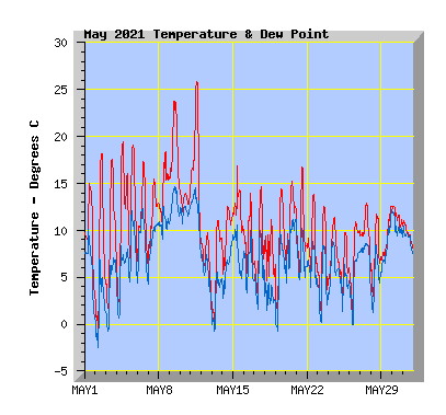
- This May just above my average temperature of 9.7c with 9.8C.
- The coldest temperature was -1.0C, my average May minimum is -1.4C.
- Two air frosts (air temperature at or below 0) were recorded, my average is 3.
- The highest temperature was 25.9CC, a new May maximum for my station. The previous record was 25.4C in 2002. My average May maximum is 22.4C.
- Two days failed to reach or exceed 10C, my average is 1 day.
- Thirteen days reached or exceeded 15C, equalling my average.
- Two days reached or exceeded 20C, my average is 3 days.
- One day reached or exceeded 25C, my average is 0. Only 3 days in 22 years of records have reached or exceeded 25C.
- Wind run was 112% of my average of 3211km with 3598km, The windiest May since 2010.
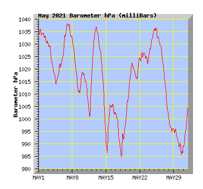
- The barometer recorded above average pressure for the month with 1015.9hPa. My average is 1012.0hPa.
- Rainfall was 259% of the average expected total of 49mm with 127mm, with 101.6mm falling from the 29th to the 31st.
- This is the wettest May in the past 10 years but not the wettest May in my records.
- The wettest May in my records is 2009 with 192.8mm, driest, 2015 with 12.5mm.
| May 2021 Summary Temperature | |
|---|---|
| Mean | 9.7 C |
| Mean Maximum | 14.8 C |
| Mean Minimum | 4.7 C |
| Maximum High | 25.9 C (11th) |
| Maximum Low | 13.4 C (9th) |
| Minimum High | 9.7 C (12th) |
| Minimum Low | -1.0 C (2nd) |
| Wind Speed and Direction | |
| Maximum Gust | 52 km/h (14th) |
| Mean | 5.1 km/h |
| Wind Run | 3598 km |
| Max Daily Windrun | 363 km (31st) |
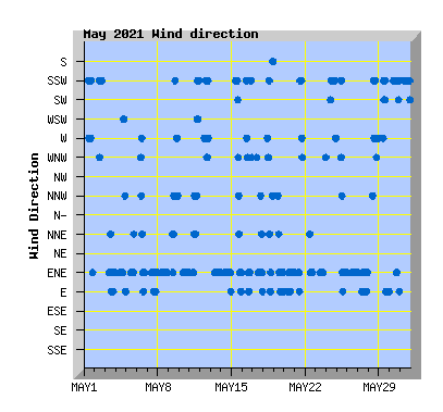
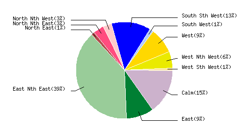
| Prevailing Direction | East North East |
| Barometer | |
| Maximum | 1038.3 hPa (7th) |
| Minimum | 984.8 hPa (18th) |
| Mean | 1015.9 hPa |
| Max Daily Change | -32.4 hPa (14th) |
| Rainfall | |
| Days with Measured Rainfall (0.2mm or more) |
12 |
| Max Daily Rainfall | 49.0 mm (30th) |
| Monthly Rainfall | 127.0 mm |
| Humidity | |
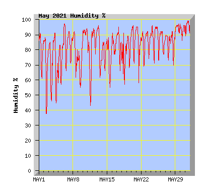
| Maximum | 99 % (31st) |
| Minimum | 37 % (2nd) |
| May Daily Observations | ||||||||||||
|---|---|---|---|---|---|---|---|---|---|---|---|---|
| Temperature | Wind | Rainfall | Barometer | |||||||||
| Date | Min | Max | Mean | Mean (Km/h) | Gust (Km/h) | Run (km) | Prevailing Dir | 10 Minute Max (mm) | Total (mm) | Min (hPa) | Max (hPa) | Change (hPa) |
| 1 | 2.4 | 15.0 | 9.5 | 1.7 | 16 | 38 | South Sth West | 0 | 0 | 1033.1 | 1036.0 | +2.9 |
| Borning cloud breaking to a sunny afternoon with light southerly winds. | ||||||||||||
| 2 | -1.0 | 18.2 | 7.3 | 1.3 | 22 | 30 | South Sth West | 0.2 | 0.2 | 1030.5 | 1034.4 | -3.9 |
| Morning frost. Clear and sunny with light breezes tending southerly. Rain total due to condensation. | ||||||||||||
| 3 | 1.3 | 17.6 | 9.0 | 2.5 | 19 | 57 | East Nth East | 0 | 0 | 1020.7 | 1030.4 | -9.7 |
| Sunny with light winds tending NE. | ||||||||||||
| 4 | 1.9 | 19.4 | 10.6 | 1.1 | 14 | 24 | East Nth East | 0 | 0 | 1013.8 | 1020.5 | -6.7 |
| Sunny with light winds tending NE. Cloud increasing in the afternoon. | ||||||||||||
| 5 | 6.6 | 19.1 | 12.6 | 2.3 | 29 | 53 | East Nth East | 0 | 0 | 1016.9 | 1024.4 | +7.5 |
| Sunny with light winds tending NE. | ||||||||||||
| 6 | 5.9 | 17.3 | 11.1 | 2.7 | 24 | 60 | West | 0 | 0 | 1024.6 | 1038.2 | +13.6 |
| Morning fog and drizzle clearing to a sunny afternoon with light winds. | ||||||||||||
| 7 | 5.8 | 15.5 | 11.6 | 7.9 | 36 | 181 | East Nth East | 0 | 0 | 1032.3 | 1038.3 | -6.0 |
| Variable cloud but mostly sunny. Cloud increasing from mid afternoon. NE wind. | ||||||||||||
| 8 | 9.8 | 18.4 | 14.2 | 5.4 | 24 | 121 | East Nth East | 0 | 0 | 1015.9 | 1032.2 | -16.3 |
| Mostly cloud but some sunny intervals. A few spots of rain in the evening. Light winds tending NE. | ||||||||||||
| 9 | 13.7 | 23.4 | 18.4 | 5.5 | 26 | 124 | East Nth East | 0 | 0 | 1010.5 | 1018.4 | +7.9 |
| Cloudy with some sunny intervals. Light variable breezes tending NE. Late-autumn scorcher for Christchurch, but South's weather in for dramatic shift |
||||||||||||
| 10 | 11.7 | 14.5 | 13.2 | 4.3 | 20 | 99 | East Nth East | 0.2 | 0.2 | 1012.9 | 1019.0 | -6.1 |
| Low misty cloud in the morning but continuing overcast. Low cloud returning in the evening with late showers. Light NE winds. Weather: A second day of record-breaking warmth - and it's not over yet |
||||||||||||
| 11 | 8.3 | 25.9 | 17.3 | 8.0 | 43 | 183 | East Nth East | 0.2 | 1.0 | 1000.9 | 1015.6 | +14.7 |
| Partly cloudy and warm with northerly winds from midday. A colder southerly change in the evening with showers. | ||||||||||||
| 12 | 1.5 | 9.7 | 6.7 | 6.8 | 35 | 156 | West | 0.8 | 15.8 | 1015.9 | 1037.0 | +21.1 |
| Morning rain easing to showers then clearing in the afternoon. Showers returning in the evening. This is the wettest day of the year to date. | ||||||||||||
| 13 | -0.6 | 11.0 | 5.9 | 6.8 | 34 | 156 | East Nth East | 0 | 0 | 1024.8 | 1036.7 | -11.9 |
| Light frost. Sunny with a cold NE wind. | ||||||||||||
| 14 | 5.0 | 12.5 | 9.5 | 14.1 | 52 | 322 | East Nth East | 0 | 0 | 991.9 | 1024.3 | -32.4 |
| A mostly sunny day with a cool NE wind. | ||||||||||||
| 15 | 8.8 | 16.9 | 12.0 | 8.4 | 48 | 192 | East Nth East | 0 | 0 | 986.5 | 1005.6 | +19.1 |
| Some morning cloud. A fresh southerly change in the morning dying away in the afternoon. | ||||||||||||
| 16 | 4.3 | 13.9 | 8.7 | 1.9 | 23 | 43 | East Nth East | 0 | 0 | 1001.8 | 1006.2 | -4.4 |
| Mostly cloudy with light breezes tending NE. Sunny intervals later in the afternoon. | ||||||||||||
| 17 | 2.2 | 14.7 | 7.7 | 1.5 | 19 | 33 | East Nth East | 0 | 0 | 988.1 | 1002.3 | -14.2 |
| High cloud breaking to a sunny afternoon with light breezes tending NE. | ||||||||||||
| 18 | 3.1 | 11.1 | 6.9 | 4.1 | 44 | 92 | West | 1.6 | 4.6 | 984.8 | 997.4 | +12.6 |
| Cold morning southerly change with rain and hail clearing to a sunny cool day with light winds. | ||||||||||||
| 19 | 0.5 | 14.4 | 7.6 | 1.0 | 12 | 22 | East Nth East | 0 | 0 | 997.6 | 1016.8 | +19.2 |
| High cloud increasing, light breezes tending NE. | ||||||||||||
| 20 | 5.1 | 15.2 | 10.9 | 6.1 | 29 | 140 | East Nth East | 0 | 0 | 1016.8 | 1022.5 | +5.7 |
| Sunny and feeling warmer. Cloud increasing and a cool NE wind later in the afternoon. | ||||||||||||
| 21 | 4.8 | 16.8 | 9.1 | 3.2 | 41 | 72 | East Nth East | 0.2 | 0.2 | 1016.1 | 1024.9 | +8.8 |
| Cloudy and mild with light winds before a southerly change blowing in early afternoon. Parched paddocks: How Canterbury farmers are adapting to the big dry |
||||||||||||
| 22 | 4.3 | 13.8 | 8.5 | 1.3 | 15 | 29 | East Nth East | 0 | 0 | 1023.1 | 1026.8 | +3.7 |
| Sunny with light winds. | ||||||||||||
| 23 | 0.9 | 12.6 | 6.1 | 2.3 | 24 | 54 | East Nth East | 0 | 0 | 1022.2 | 1026.5 | +4.3 |
| Sunny with light NE winds in the afternoon. | ||||||||||||
| 24 | 3.7 | 11.4 | 7.7 | 7.7 | 39 | 175 | South Sth West | 0.2 | 1.6 | 1027.1 | 1035.9 | +8.8 |
| Cloudy with showers and cool southerly winds. | ||||||||||||
| 25 | 1.5 | 9.8 | 5.8 | 2.3 | 19 | 51 | East Nth East | 0.2 | 1.0 | 1031.6 | 1036.7 | -5.1 |
| Early showers clearing by dawn with cloud clearing to a sunny and cool day with light NE winds. | ||||||||||||
| 26 | 0.7 | 10.9 | 6.9 | 8.0 | 32 | 182 | East Nth East | 0 | 0 | 1019.4 | 1031.4 | -12.0 |
| Morning frost. Sunny with some cloud later in the afternoon, NE wind. | ||||||||||||
| 27 | 5.2 | 12.9 | 9.8 | 8.9 | 34 | 203 | East Nth East | 0 | 0 | 1000.4 | 1019.1 | -18.7 |
| Sunny with a NE wind, cloud increasing later in the afternoon. | ||||||||||||
| 28 | 2.6 | 11.7 | 7.0 | 1.7 | 22 | 39 | West | 0.2 | 0.4 | 995.2 | 1000.3 | -5.1 |
| Showers from morning with some sunny intervals in the afternoon. Light winds tending westerly. | ||||||||||||
| 29 | 6.6 | 12.6 | 9.1 | 4.6 | 51 | 105 | East | 1.2 | 13.8 | 990.6 | 996.6 | -5.5 |
| Early rain clearing for a time but returning in the afternoon with easterly winds increasing. | ||||||||||||
| 30 | 10.1 | 12.6 | 11.2 | 8.1 | 50 | 184 | East | 1.6 | 48.8 | 985.7 | 990.8 | -5.1 |
| Rain heavy at times with variable winds tending easterly. Flooding in some parts of the city. Very high rainfall in the foothills lead to severe flooding in mid and south canterbury with civil defence emergencies being declared. Wild weather explained: The science of the Canterbury storm causing havoc |
||||||||||||
| 31 | 7.9 | 11.0 | 9.6 | 15.9 | 47 | 363 | South Sth West | 1.2 | 39.0 | 988.8 | 1005.0 | +16.2 |
| More rain and southerly winds add to the floods causing evacuations in several areas. Canterbury flooding in pictures: Heavy rain and rising floodwaters hit hard Canterbury floods: Travel warning as highways and bridges remain closed across region |
||||||||||||