January Summary
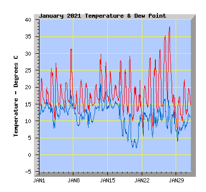
New maximum temperature record of 38C for January and my station, Average temperature and wind run for the month, 54% of expected rainfall.
(January compared to my records from the past 10 years.)
- This January was equal to my average temperature of 17.5C.
- The coldest temperature was 5.6C, close to my average minimum of 5.8C.
- The highest temperature was 38C a new January record and all time station record. The previous station and January record was 37.2C in January 2009.
- Twenty seven days reached or exceeded 20C, my average is 24.
- Thirteen days reached or exceeded 25C, my average is 12.
- Four days reached or exceeded 30C, my average is 5.
- Two days reached or exceeded 35C, my average is 0 though 2018 had 2 days and 2016 and 2009 had 1 day that also reached or exceeded 35C.
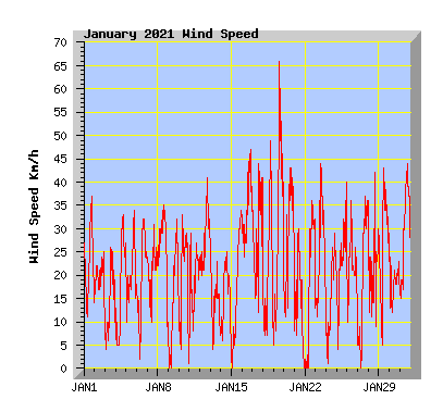
- Wind run was 102% of my average of 5347km with 5480km.
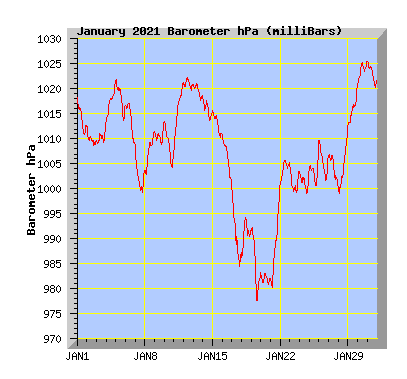
- The barometer recorded below average pressure for the month with 1007.4hPa. My average is 1010.0hPa.
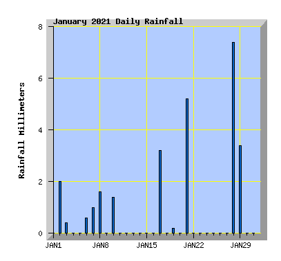
- Rainfall was 54% of the average expected total of 48mm with 26mm,
- The driest January in the past 10 years is 2020 with just 4mm, is also the driest January in my records.
- The wettest January in the past 10 years and in all my January records is 2018 with 104mm.
| January 2021 Summary Temperature | |
|---|---|
| Mean | 17.5 C |
| Mean Maximum | 24.6 C |
| Mean Minimum | 12.3 C |
| Maximum High | 38.0 C (27th) |
| Maximum Low | 16.0 C (16th) |
| Minimum High | 17.3 C (29th) |
| Minimum Low | 5.6 C (29th) |
| Wind Speed and Direction | |
| Maximum Gust | 66 km/h (19th) |
| Mean | 7.7 km/h |
| Wind Run | 5480 km |
| Max Daily Windrun | 299 km (16th) |
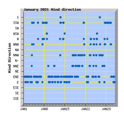
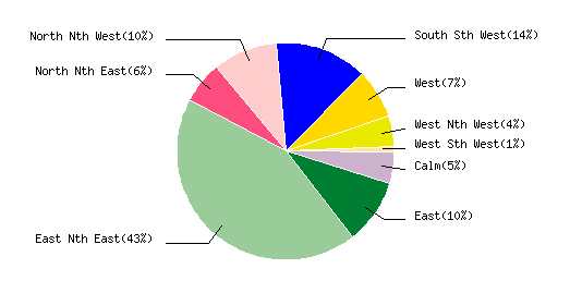
| Prevailing Direction | East North East |
| Barometer | |
| Maximum | 1025.8 hPa (30th) |
| Minimum | 977.4 hPa (19th) |
| Mean | 1007.4 hPa |
| Max Daily Change | +20.9 hPa (21st) |
| Rainfall | |
| Days with Measured Rainfall (0.2mm or more) |
11 |
| Max Daily Rainfall | 7.4 mm (28th) |
| Monthly Rainfall | 26.4 mm |
| Humidity | |
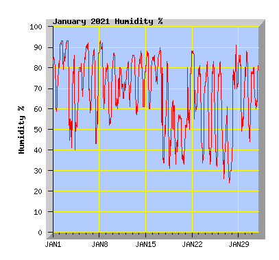
| Maximum | 94 % (28th) |
| Minimum | 24 % (27th) |
| January Daily Observations | ||||||||||||
|---|---|---|---|---|---|---|---|---|---|---|---|---|
| Temperature | Wind | Rainfall | Barometer | |||||||||
| Date | Min | Max | Mean | Mean (Km/h) | Gust (Km/h) | Run (km) | Prevailing Dir | 10 Minute Max (mm) | Total (mm) | Min (hPa) | Max (hPa) | Change (hPa) |
| 1 | 14.6 | 22.6 | 17.3 | 8.1 | 37 | 182 | East Nth East | 0 | 0 | 1010.7 | 1018.5 | -7.8 |
| Morning cloud breaking with sunny intervals, cloud increasing later in the afternoon, NE winds freshening in the afternoon. | ||||||||||||
| 2 | 15.0 | 20.0 | 16.3 | 6.3 | 25 | 144 | East Nth East | 0.4 | 2.0 | 1008.5 | 1012.6 | -4.1 |
| Overcast with morning drizzle and occasional afternoon showers, NE wind. Wild weather: South Island flooding causes havoc, more than 1000 lightning strikes detected across the North Island |
||||||||||||
| 3 | 13.7 | 25.6 | 18.6 | 4.1 | 26 | 92 | East Nth East | 0.2 | 0.4 | 1008.8 | 1013.4 | +4.6 |
| Morning cloud breaking. A few spots of rain around midday but a mostly sunny and warm afternoon. Light NE winds. Severe thunderstorm brings torrential rain and hail to Timaru and Waimate |
||||||||||||
| 4 | 10.0 | 27.2 | 17.5 | 6.2 | 33 | 141 | East Nth East | 0 | 0 | 1013.7 | 1021.4 | +7.7 |
| Warm morning with variable breezes tending northerly. Cooler NE wind from midday. | ||||||||||||
| 5 | 13.5 | 21.0 | 16.7 | 7.2 | 34 | 164 | East Nth East | 0 | 0 | 1013.7 | 1021.9 | -8.2 |
| Cloud increasing and a few spots of rain in the afternoon. NE winds freshening in the evening. | ||||||||||||
| 6 | 13.5 | 21.4 | 17.2 | 7.1 | 32 | 162 | East Nth East | 0.2 | 0.6 | 1009.0 | 1017.2 | -8.2 |
| Morning drizzle clearing and cloud breaking by midday to a sunny and mild afternoon. NE wind. | ||||||||||||
| 7 | 15.4 | 31.3 | 20.8 | 7.7 | 31 | 176 | East Nth East | 0.2 | 1.0 | 999.4 | 1008.7 | -9.3 |
| Morning cloud breaking then sunny and hot with light southerly winds from midday. Showers in the afternoon and evening. Hey, Niwa – what happened to our long, hot summer? |
||||||||||||
| 8 | 12.3 | 19.0 | 14.6 | 11.0 | 35 | 251 | South Sth West | 0.2 | 1.6 | 1002.9 | 1011.4 | +8.5 |
| Overcast with morning drizzle. Cloud breaking with sunny intervals in the afternoon, cool southerly winds. | ||||||||||||
| 9 | 11.6 | 22.2 | 16.3 | 5.0 | 32 | 112 | East Nth East | 0 | 0 | 1008.8 | 1013.3 | +4.5 |
| Overcast and calm morning. Cloud breaking with NE wind in the afternoon. | ||||||||||||
| 10 | 12.4 | 21.3 | 16.6 | 7.3 | 33 | 162 | East Nth East | 0.6 | 1.4 | 1004.1 | 1013.5 | -9.4 |
| Morning showers and drizzle clearing and cloud breaking to a sunny and mild afternoon. NE wind. | ||||||||||||
| 11 | 12.3 | 18.3 | 15.1 | 6.5 | 29 | 147 | East Nth East | 0 | 0 | 1007.2 | 1021.4 | +14.2 |
| Cloudy with a southerly wind turning NE about midday. | ||||||||||||
| 12 | 14.6 | 20.8 | 17.1 | 10.6 | 41 | 243 | East Nth East | 0 | 0 | 1019.8 | 1022.4 | -2.6 |
| Morning cloud with some drizzle. Cloud breaking in the afternoon with a freshening NE wind. 47 months and counting without a colder-than-normal month - when will it break? |
||||||||||||
| 13 | 14.9 | 29.9 | 20.3 | 3.9 | 24 | 88 | East Nth East | 0 | 0 | 1017.6 | 1021.1 | -3.5 |
| Morning low cloud breaking and clearing by midday. Sunny and warm with light variable winds tending NE. | ||||||||||||
| 14 | 15.4 | 27.5 | 18.8 | 5.9 | 25 | 134 | East Nth East | 0 | 0 | 1013.8 | 1018.1 | -4.3 |
| Low cloud breaking and clearing after midday to a sunny afternoon, hazy with increasing cloud later in the afternoon. west to SW winds turning NE later in the afternoon. Christchurch residents restricted to watering gardens on alternate days |
||||||||||||
| 15 | 15.6 | 24.7 | 18.8 | 6.5 | 34 | 148 | East Nth East | 0 | 0 | 1010.2 | 1015.6 | -5.4 |
| Morning cloud breaking to a sunny day with NE winds freshening later in the afternoon. | ||||||||||||
| 16 | 16.0 | 20.7 | 17.9 | 13.1 | 47 | 299 | East Nth East | 0 | 0 | 1000.4 | 1010.9 | -10.5 |
| Cloudy with a fresh NE wind. | ||||||||||||
| 17 | 15.1 | 27.9 | 20.1 | 10.4 | 44 | 248 | East Nth East | 1.2 | 3.2 | 984.5 | 1000.0 | -15.5 |
| Morning cloud and a period or rain before midday. Cloud breaking and winds turning warm northerly in the afternoon. | ||||||||||||
| 18 | 10.3 | 25.2 | 16.8 | 7.0 | 49 | 160 | North Nth West | 0 | 0 | 986.3 | 994.3 | +8.0 |
| Variable cloud, winds light in the morning, gusty warm northerly in the afternoon. Rain or sunshine? Why do weather forecasts sometimes tell different stories? |
||||||||||||
| 19 | 10.8 | 29.3 | 17.5 | 11.2 | 66 | 256 | North Nth West | 0.2 | 0.2 | 977.4 | 992.2 | -14.8 |
| Sunny with gusty nor 'west winds. Cloud increasing in the afternoon with a brief shower and cooler temperatures. Summer snow in South Island as winter comes early |
||||||||||||
| 20 | 9.2 | 20.2 | 14.8 | 10.1 | 43 | 231 | North Nth West | 0 | 0 | 980.7 | 983.2 | -2.5 |
| Variable cloud with sunny intervals and gusty nor'west winds. | ||||||||||||
| 21 | 11.9 | 22.1 | 14.5 | 3.6 | 30 | 83 | South Sth West | 1.6 | 5.2 | 980.1 | 1001.0 | +20.9 |
| Mostly cloudy with afternoon showers, some heavy. Light winds tending southerly. | ||||||||||||
| 22 | 7.2 | 20.4 | 15.2 | 7.2 | 36 | 162 | East Nth East | 0 | 0 | 1001.1 | 1005.8 | +4,7 |
| Some cloud, NE wind. New Zealand weather: Who's had the most sunshine so far this year? |
||||||||||||
| 23 | 11.7 | 28.7 | 19.3 | 8.9 | 44 | 204 | East Nth East | 0 | 0 | 999.3 | 1004.4 | -5.1 |
| High cloud, warm northerly winds turning cooler westerly from evening. | ||||||||||||
| 24 | 7.7 | 28.2 | 17.8 | 4.8 | 29 | 110 | East Nth East | 0 | 0 | 999.0 | 1003.7 | +4.7 |
| High cloud and with sunny periods, NE winds turning northerly in the evening. NZ's weird summer: Drought in the north, drenched in the south |
||||||||||||
| 25 | ||||||||||||
| Sunny with high cloud, warm northerly winds from mid afternoon. 'Atmospheric rivers' drive New Zealand's wet and extreme weather |
||||||||||||
| 26 | 13.4 | 35.2 | 23.4 | 8.0 | 36 | 182 | East Nth East | 0 | 0 | 1001.8 | 1009.9 | -8.1 |
| Sunny and very warm in the afternoon with a late NW change pushing the temperature up to 35.2 at 7:10pm. Hot in the city: Temperature records broken across Canterbury |
||||||||||||
| 27 | 15.0 | 38.0 | 26.3 | 7.9 | 37 | 179 | North Nth West | 0 | 0 | 1000.0 | 1007.1 | -7.1 |
| Sunny and hot with nor'west winds. High cloud increasing in the afternoon. 38C recorded at 3pm before cloud cover started reducing the temperature. Why does some of New Zealand see near 40C temperatures? |
||||||||||||
| 28 | 10.1 | 22.2 | 15.2 | 6.4 | 42 | 146 | South Sth West | 1.8 | 7.4 | 999.0 | 1012.4 | +13.4 |
| Mostly cloudy with a period of rain in the afternoon with a gusty southerly wind. Rain clearing and wind dying away later in the afternoon. Timaru in for cold snap as thunderstorm breaks heatwave |
||||||||||||
| 29 | 5.6 | 17.3 | 12.1 | 10.7 | 43 | 244 | South Sth West | 0.6 | 3.4 | 1012.6 | 1020.8 | +8.2 |
| Showers clearing by dawn. Morning cloud breaking to a sunny afternoon with southerly wind Golden weather likely to continue for two weeks, with little chance of rain |
||||||||||||
| 30 | 9.9 | 22.2 | 14.4 | 6.2 | 24 | 141 | South Sth West | 0 | 0 | 1021.0 | 1025.8 | +4.8 |
| Morning cloud with some drizzle clearing to a sunny afternoon with light winds. | ||||||||||||
| 31 | 11.8 | 19.6 | 15.6 | 12.3 | 44 | 282 | East Nth East | 0 | 0 | 1020.3 | 1025.5 | -5.2 |
| Morning cloud breaking to a sunny afternoon with a fresh NE wind. | ||||||||||||