February Summary
Above average temperature, warmer than January, above average wind run and second lowest rainfall in the past 10 years
(February compared to my records from the past 10 years.)
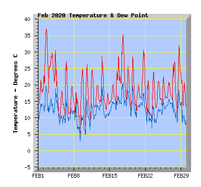
- This February is above my average temperature of 17.1C with 17.9C. My February record is 19.4C in 2016.
- The warmest temperature was 37.0C, a new February record.
- The coldest temperature was 4.6C, the lowest February temperature I've recorded in the past 10 years is 3.8C in 2017.
- Twenty four days reached or exceeded 20C, my average is 21 days.
- Thirteen days reached or exceeded 25C, my average is 9 days.
- Five days reached or exceeded 30C, my average is 3 days.
- Two days reached or exceeded 35C, my average is 0 though 2 days have done this in the past, in 2009 and 2017.
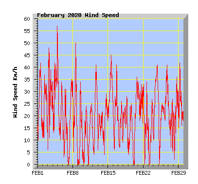
- Wind run was 107% of my average of 4516km with 4819km.
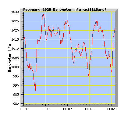
- The barometer recorded below average pressure for the month with 1012.7hPa. My average is 1013.7hPa.
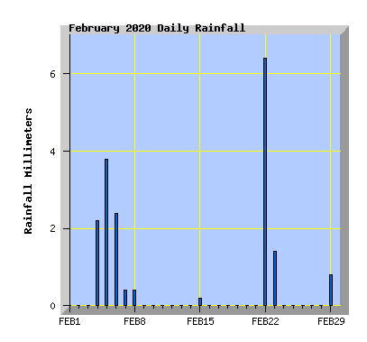
- Rainfall was the second lowest I've ever recorded for February in the past 10 years, 49% of the average expected total of 37mm. The previous dry February was 2015 with 12mm.
- The wettest February in the past 10 years and in my 20 years of records is 2018 with 132mm.
| February 2020 Summary Temperature | |
|---|---|
| Mean | 17.9 C |
| Mean Maximum | 25.0 C |
| Mean Minimum | 12.4 C |
| Maximum High | 37.0 C (2nd) |
| Maximum Low | 18.7 C (17th) |
| Minimum High | 17.6 C (14th) |
| Minimum Low | 4.6 C (9th) |
| Wind Speed and Direction | |
| Maximum Gust | 57 km/h (4th) |
| Mean | 7.3 km/h |
| Wind Run | 4819 km |
| Max Daily Windrun | 282 km (4th) |
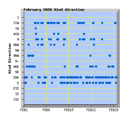
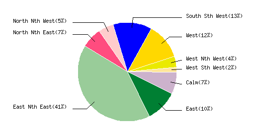
| Prevailing Direction | East North East |
| Barometer | |
| Maximum | 1028.9 hPa (7th) |
| Minimum | 987.1 hPa (4th) |
| Mean | 1012.7 hPa |
| Max Daily Change | +23.2 hPa (29th) |
| Rainfall | |
| Days with Measured Rainfall (0.2mm or more) |
9 |
| Max Daily Rainfall | 6.4 mm (22nd) |
| Monthly Rainfall | 18 mm |
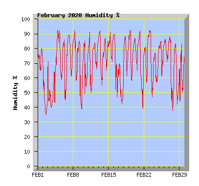
| Humidity | |
| Maximum | 95 % (19th) |
| Minimum | 35 % (2nd) |
| February Daily Observations | ||||||||||||
|---|---|---|---|---|---|---|---|---|---|---|---|---|
| Temperature | Wind | Rainfall | Barometer | |||||||||
| Date | Min | Max | Mean | Mean (Km/h) | Gust (Km/h) | Run (km) | Prevailing Dir | 10 Minute Max (mm) | Total (mm) | Min (hPa) | Max (hPa) | Change (hPa) |
| 1 | 13.5 | 21.4 | 17.0 | 9.5 | 42 | 215 | East Nth East | 0 | 0 | 1004.4 | 1016.2 | -11.8 |
| Cloudy with NE winds freshening in the afternoon. | ||||||||||||
| 2 | 17.8 | 37.0 | 27.7 | 7.4 | 37 | 170 | North Nth West | 0 | 0 | 998.8 | 1004.0 | -5.2 |
| Hot and mostly cloudy with some sunny intervals. Hazy with Australian bush fire smoke making the sun orange on the afternoon. New February record temperature for my station. The previous records was 36.1C on 9th Feb 2009. | ||||||||||||
| 3 | 17.3 | 29.8 | 25.3 | 9.2 | 48 | 210 | North Nth West | 0 | 0 | 997.9 | 1001.9 | -4.0 |
| Overcast with a nor'west arch over the city for most of the day. Warm northerly winds. | ||||||||||||
| 4 | 11.8 | 30.6 | 20.6 | 12.3 | 57 | 282 | South Sth West | 0.4 | 2.2 | 987.1 | 998.4 | +11.3 |
| Mostly cloudy with warm nor'west winds in the morning. A change to cooler southerly winds from late morning with showers in the evening. Maximum temperature recorded at 10:10am Scorching run coming to an end, but it's going to keep getting dryer in many places |
||||||||||||
| 5 | 9.7 | 18.2 | 13.3 | 9.0 | 45 | 206 | East Nth East | 0.6 | 3.6 | 999.6 | 1015.6 | +16.0 |
| Morning showers with a southerly wind clearing mid morning. Cloud breaking and wind turning NE in the afternoon. Rainfall in Gore nearly four times the monthly average as intense flooding hits History of floods in Southland, the worst recorded in 1984 Floods, drought, snow and a spring-like capital - New Zealand's stark weather contrasts |
||||||||||||
| 6 | 9.5 | 27.3 | 16.4 | 4.1 | 31 | 93 | South Sth West | 0.8 | 2.4 | 1013.6 | 1027.8 | +14.2 |
| Sunny morning with variable breezes tending southerly in the afternoon with increasing cloud. A period of rain in the evening. Floods a glimpse of the future as climate warming steps up |
||||||||||||
| 7 | 11.1 | 19.6 | 14.8 | 6.5 | 35 | 149 | East Nth East | 0.2 | 0.2 | 1019.5 | 1028.9 | -9.4 |
| Early showers clearing by dawn. Cloud breaking to a mostly sunny afternoon with a freshening NE wind. | ||||||||||||
| 8 | 9.6 | 17.7 | 13.2 | 7.6 | 50 | 173 | South Sth West | 0.2 | 0.4 | 1014.3 | 1022.4 | +8.1 |
| Mostly cloudy with some light showers and a cool southerly wind. | ||||||||||||
| 9 | 4.6 | 24.9 | 14.8 | 4.0 | 34 | 89 | South Sth West | 0 | 0 | 1016.2 | 1022.2 | -6.0 |
| Cool with some cloud in the morning. Cloud clearing to a sunny afternoon with southerly winds dying away and turning NE late afternoon. | ||||||||||||
| 10 | 7.2 | 26.3 | 15.3 | 3.7 | 24 | 85 | East Nth East | 0 | 0 | 1017.6 | 1022.0 | -4.4 |
| Clear and sunny with light southerly winds turning NE in the afternoon. Smattering of rain offers little relief for Christchurch's parched hills |
||||||||||||
| 11 | 8.9 | 24.8 | 15.9 | 5.6 | 25 | 127 | West | 0 | 0 | 1016.8 | 1021.9 | +5.1 |
| Sunny with light winds tending westerly. | ||||||||||||
| 12 | 12.0 | 19.9 | 16.0 | 8.1 | 41 | 185 | East Nth East | 0 | 0 | 1012.6 | 1021.9 | -9.3 |
| Variable cloud NE winds freshening in the afternoon. | ||||||||||||
| 13 | 14.2 | 28.7 | 18.6 | 6.1 | 22 | 139 | West | 0 | 0 | 1012.8 | 1023.3 | +10.5 |
| Morning cloud breaking to a sunny warm afternoon with light variable winds. Port Hills reaches extreme fire danger levels similar to deadly 2017 blaze Cyclone warning: Ex-tropical cyclone Uesi on track to bring heavy rain to South Island |
||||||||||||
| 14 | 12.3 | 17.6 | 14.4 | 6.4 | 29 | 144 | East Nth East | 0 | 0 | 1022.9 | 1025.5 | +2.6 |
| Morning cloud with some drizzle clearing by midday but remaining mostly cloudy with a NE wind. | ||||||||||||
| 15 | 14.5 | 20.2 | 16.6 | 11.9 | 45 | 272 | East Nth East | 0.2 | 0.2 | 1014.7 | 1024.9 | -10.2 |
| Morning drizzle clearing but remaining cloudy with a fresh NE wind. Weather: Record dry spell for Auckland, South faces deluge from cyclone Uesi |
||||||||||||
| 16 | 13.7 | 28.8 | 20.4 | 8.0 | 41 | 182 | East Nth East | 0 | 0 | 1001.2 | 1014.5 | -13.3 |
| Mostly cloudy with a few spots of rain in the morning, north to NE winds in the afternoon. | ||||||||||||
| 17 | 18.7 | 35.4 | 25.8 | 4.1 | 26 | 93 | East Nth East | 0 | 0 | 1003.3 | 1011.4 | +8.1 |
| Mostly cloudy and hot with sunny intervals in the afternoon. Light variable winds tending NE | ||||||||||||
| 18 | 15.2 | 25.6 | 19.1 | 7.8 | 28 | 179 | West | 0 | 0 | 1007.2 | 1012.2 | -5.5 |
| Partly cloudy, variable winds tending westerly. | ||||||||||||
| 19 | 12.1 | 28.6 | 17.8 | 5.1 | 25 | 117 | West | 0 | 0 | 1005.7 | 1013.5 | +7.8 |
| Morning fog and mist clearing to a sunny day with light west to SW winds. | ||||||||||||
| 20 | 11.1 | 20.3 | 15.8 | 6.8 | 36 | 154 | East Nth East | 0 | 0 | 1006.4 | 1013.5 | -7.1 |
| Mostly cloudy with NE winds freshening in the afternoon. MetService, Niwa, grilled over forecaster 'double-up' |
||||||||||||
| 21 | 15.5 | 30.6 | 21.7 | 9.5 | 34 | 216 | East Nth East | 0 | 0 | 995.1 | 1006.2 | -11.1 |
| Variable cloud with NE winds, warm in the afternoon. Flash flood in Hokitika after sky 'just opened up' Front brings heavy rain to South Island west but only light relief to driest areas |
||||||||||||
| 22 | 10.6 | 21.5 | 14.6 | 5.8 | 34 | 131 | West | 1.0 | 6.4 | 1002.6 | 1019.1 | +16.5 |
| Mostly cloudy with a period of rain from late afternoon. | ||||||||||||
| 23 | 7.4 | 24.0 | 15.4 | 3.8 | 27 | 86 | East Nth East | 0.4 | 1.4 | 1019.2 | 1025.6 | +6.4 |
| Early showers clearing by dawn to a sunny day with light breezes in the morning, NE in the afternoon | ||||||||||||
| 24 | 12.5 | 21.2 | 16.8 | 11.4 | 41 | 262 | East Nth East | 0 | 0 | 1019.1 | 1025.7 | -6.6 |
| Sunny with NE winds freshening in the afternoon. NZ's big dry and climate change: What's the link? North Canterbury farmers urged to prepare as region dries out |
||||||||||||
| 25 | 13.2 | 22.5 | 16.8 | 5.3 | 28 | 122 | East Nth East | 0 | 0 | 1019.3 | 1021.9 | -2.6 |
| Overcast with NE winds from midday. | ||||||||||||
| 26 | 16.1 | 20.8 | 17.6 | 9.9 | 41 | 226 | East Nth East | 0 | 0 | 1009.6 | 1020.3 | -10.7 |
| Overcast with NE winds, cloud breaking later in the afternoon. | ||||||||||||
| 27 | 14.8 | 27.1 | 20.3 | 4.6 | 27 | 104 | East Nth East | 0 | 0 | 1004.4 | 1009.4 | -5.0 |
| Overcast with a nor'west arch, light variable winds tending NE. | ||||||||||||
| 28 | 11.2 | 31.9 | 20.8 | 8.1 | 36 | 186 | East Nth East | 0 | 0 | 997.1 | 1008.6 | -11.5 |
| Variable cloud, warm N to NE winds | ||||||||||||
| 29 | 12.5 | 21.9 | 17.0 | 9.0 | 42 | 207 | South Sth West | 0.4 | 0.8 | 997.8 | 2021.0 | +23.2 |
| Early morning southerly change with a few showers. Cloud breaking in the afternoon with wind turning NE. | ||||||||||||
p>