November Summary
New record average temperature for November, almost equal to December. Above average rainfall and below average wind run and barometer.
Stuff article: November's 'unsettled' weather brought record-breaking heat
(November compared to my records from the past 10 years.)
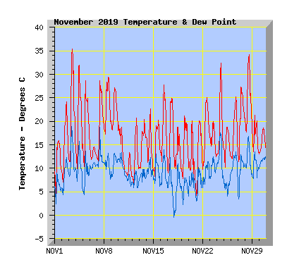
- This November is a new record average temperature with 16.2C, my November 10 year average is 13.9C. My previous record was 15.1C in 2017.
- The warmest temperature was 35.4C, another November record,the previous records was 33C in 2016.
- The coldest temperature was 3.7C, the lowest November temperature I've recorded is -1.2C in 2010.
- Twenty nine days reached or exceeded 15C, my average is 27.
- Twenty two days reached or exceeded 20C, my average is 15.
- Twelve days reached or exceeded 25C, my average is 6.
- Four days reached or exceeded 30C, my average is 1.
- One day reached or exceeded 35C, for the first tme on my records.
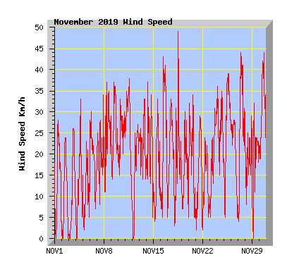
- Wind run was 95% of my average of 4995km with 4760km.
- The windiest November in the past 10 years was 2011 with 5475km.
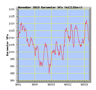
- The barometer recorded below average average pressure for the month with 1006.1hPa. My average is 1010.1hPa.
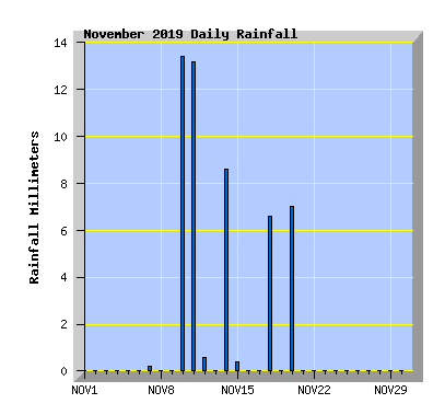
- Rainfall 17% above the average expected total of 42.5mm with 50mm.
- The wettest November in the past 10 years is 2018 with 88.5mm.
- The driest November in the past 10 years is 2015 with 14.0mm
Updated 5 December 2020
| November 2019 Summary Temperature | |
|---|---|
| Mean | 16.2 C |
| Mean Maximum | 23.6 C |
| Mean Minimum | 9.9 C |
| Maximum High | 35.4 C (3rd) |
| Maximum Low | 17.2 C (9th) |
| Minimum High | 13.4 C (11th) |
| Minimum Low | 3.7 C (1st) |
| Wind Speed and Direction | |
| Maximum Gust | 49 km/h (18th) |
| Mean | 6.9 km/h |
| Wind Run | 4760 km |
| Max Daily Windrun | 274 km (11th) |
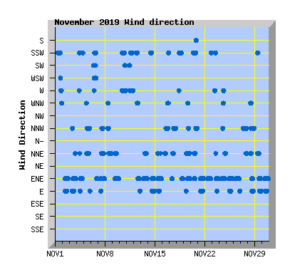
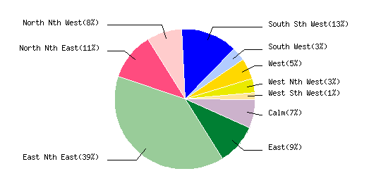
| Prevailing Direction | East North East |
| Barometer | |
| Maximum | 1022.4 hPa (29th) |
| Minimum | 984.4 hPa (14th) |
| Mean | 1006.1 hPa |
| Max Daily Change | `+20.7 hPa (20th) |
| Rainfall | |
| Days with Measured Rainfall (0.2mm or more) |
7 |
| Max Daily Rainfall | 13.4 mm (10th) |
| Monthly Rainfall | 50.0 mm |
| Humidity | |
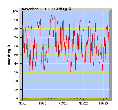
| Maximum | 95 % (11th) |
| Minimum | 27 % (3rd) |
| November Daily Observations | ||||||||||||
|---|---|---|---|---|---|---|---|---|---|---|---|---|
| Temperature | Wind | Rainfall | Barometer | |||||||||
| Date | Min | Max | Mean | Mean (Km/h) | Gust (Km/h) | Run (km) | Prevailing Dir | 10 Minute Max (mm) | Total (mm) | Min (hPa) | Max (hPa) | Change (hPa) |
| 1 | 3.7 | 15.9 | 11.1 | 4.8 | 29 | 109 | South Sth West | 0 | 0 | 1009.5 | 1019.4 | +9.9 |
| Light morning frost, sunny through thin high cloud with southerly winds. | ||||||||||||
| 2 | 6.6 | 24.2 | 14.8 | 3.6 | 24 | 83 | East Nth East | 0 | 0 | 1014.9 | 1020.6 | -5.7 |
| Sunny and mild with some high cloud, light NE wind. | ||||||||||||
| 3 | 10.7 | 35.4 | 21.2 | 3.6 | 26 | 82 | East Nth East | 0 | 0 | 1014.4 | 1018.8 | -4.4 |
| Sunny and very warm around midday with virtually no wind. Cooler NE wind from mid afternoon. New record temperature for November. | ||||||||||||
| 4 | 9.2 | 31.9 | 19.3 | 3.9 | 33 | 88 | East Nth East | 0 | 0 | 1007.4 | 1016.9 | -9.5 |
| Sunny and warm with light winds, NE from midday. | ||||||||||||
| 5 | 9.1 | 28.6 | 18.6 | 1.9 | 23 | 42 | North Nth East | 0 | 0 | 1003.8 | 1009.3 | -5.5 |
| Extensive high cloud, light winds from the north. | ||||||||||||
| 6 | 11.7 | 15.7 | 13.0 | 7.9 | 30 | 182 | South West | 0 | 0 | 1005.0 | 1010.2 | +5.2 |
| Overcast with a few spots of rain in the afternoon, southerly winds. Two cooler than average months in a row for the first time in nearly three years |
||||||||||||
| 7 | 11.5 | 28.7 | 19.3 | 6.4 | 34 | 146 | East Nth East | 0.2 | 0.2 | 1001.4 | 1007.8 | -6.4 |
| Showers clearing before dawn. Extensive cloud but some sunny intervals in the afternoon.Warm north to NE winds. | ||||||||||||
| 8 | 16.1 | 29.4 | 22.8 | 8.3 | 37 | 189 | North Nth East | 0 | 0 | 997.0 | 1004.2 | +7.2 |
| Some high cloud with warm northerly winds. | ||||||||||||
| 9 | 17.2 | 27.1 | 21.7 | 9.5 | 37 | 217 | East Nth East | 0 | 0 | 993.2 | 1004.2 | -11.0 |
| Overcast with warm northerly winds turning NE from mid afternoon. | ||||||||||||
| 10 | 9.2 | 19.2 | 14.7 | 9.8 | 33 | 233 | South Sth West | 1.0 | 13.4 | 989.9 | 993.6 | +3.7 |
| Mostly cloudy but some sunny intervals around midday. Cloud increasing with rain from mid afternoon. Southerly winds. Smoke and dust from Australian wildfires affects New Zealand |
||||||||||||
| 11 | 8.1 | 13.4 | 9.5 | 12.0 | 38 | 274 | South West | 0.6 | 13.0 | 989.8 | 1000.5 | +10.7 |
| Rain clearing from midday, cold southerly wind. | ||||||||||||
| 12 | 6.3 | 20.7 | 11.8 | 5.2 | 27 | 118 | South Sth West | 0.2 | 0.4 | 1000.8 | 1006.4 | +5.6 |
| Early showers clearing before dawn. Morning cloud breaking to a sunny and mild afternoon with southerly winds turning NE later in the afternoon. | ||||||||||||
| 13 | 9.9 | 20.4 | 14.7 | 8.7 | 33 | 199 | East Nth East | 0 | 0 | 989.5 | 1004.9 | -15.4 |
| Overcast with a NE wind turning northerly from late afternoon. Maximum temperature recorded at 6:10pm. | ||||||||||||
| 14 | 9.6 | 22.7 | 14.2 | 8.3 | 37 | 189 | East Nth East | 1.0 | 8.6 | 984.4 | 994.4 | +10.0 |
| Variable cloud with southerly winds. A change to NE with a few spots of rain and a rumble of thunder in the afternoon. A period of rain at night. | ||||||||||||
| 15 | 7.0 | 20.2 | 14.5 | 4.6 | 33 | 104 | East Nth East | 0.2 | 0.2 | 993.4 | 1001.1 | +7.7 |
| Any showers clearing before dawn. Mostly sunny with some high cloud, east to NE winds. | ||||||||||||
| 16 | 10.3 | 27.7 | 18.1 | 7.0 | 43 | 159 | North Nth West | 0 | 0 | 998.0 | 1005.8 | +7.8 |
| Variable high cloud, warm northerly winds. | ||||||||||||
| 17 | 7.9 | 24.9 | 16.7 | 6.9 | 33 | 158 | North Nth West | 0 | 0 | 1000.8 | 1007.5 | -6.7 |
| Sunny with some high cloud at times, warm northerly winds from midday. | ||||||||||||
| 18 | 6.5 | 18.8 | 12.4 | 5.6 | 49 | 129 | South Sth West | 2.2 | 6.6 | 997.0 | 1005.0 | +8.0 |
| Morning cloud breaking so a sunny day. Afternoon thunder storm with heavy rain and hail produced a damaging tornado in town. Minimum temperature recorded at 2:20pm with the passage of the storm, maximum temperature recorded 12:40pm. Two people injured, buildings damaged, asbestos warning after tornado hits Christchurch |
||||||||||||
| 19 | 6.9 | 21.2 | 14.1 | 5.3 | 30 | 121 | East Nth East | 0 | 0 | 994.4 | 1004.4 | -10.0 |
| Mostly cloudy with sunny intervals late in the day. Variable winds tending NE. | ||||||||||||
| 20 | 6.4 | 20.1 | 11.2 | 6.2 | 34 | 142 | South Sth West | 2.2 | 7.0 | 994.7 | 1015.4 | +20.7 |
| Morning cloud breaking to be sunny by mid morning. Afternoon thunderstorm with heavy rain but none of the hail that caused damaged in Timaru. See report below. Lightning and thunder hits Canterbury 'like a sledgehammer' |
||||||||||||
| 21 | 3.8 | 20.1 | 12.6 | 5.0 | 29 | 114 | East Nth East | 0 | 0 | 1013.5 | 1016.7 | -3.2 |
| Frost visible on some roofs in the morning. Sunny with thin high cloud, NE wind. How AI is about to take us back into NZ's weather past Huge hail stones explained after Canterbury storm sees cars dented, windows broken |
||||||||||||
| 22 | 8.9 | 25.1 | 17.9 | 4.4 | 24 | 100 | East Nth East | 0 | 0 | 1007.3 | 1014.2 | -6.9 |
| High cloud increasing in the afternoon, with NE winds turning southerly in the evening. 'Unusually warm' days ahead as summer takes hold |
||||||||||||
| 23 | 12.2 | 19.9 | 15.7 | 6.8 | 31 | 155 | East Nth East | 0 | 0 | 1009.1 | 1019.3 | -10.2 |
| Cloudy with smoke from the bush fires in Australia, West to SW winds in the morning turning NE in the afternoon. | ||||||||||||
| 24 | 12.6 | 32.4 | 18.1 | 10.4 | 36 | 238 | East Nth East | 0 | 0 | 1003.1 | 1016.9 | +13.8 |
| Morning high cloud breaking form midday to a sunny and warm afternoon. NE wind turning dying away and turning warm northerly in the afternoon before the NE returning later in the afternoon. Smoke haze from the bush fires in Australia more visible than yesterday. Australian bushfires push up New Zealand temperatures |
||||||||||||
| 25 | 9.9 | 18.8 | 14.8 | 10.6 | 39 | 241 | East Nth East | 0 | 0 | 1016.0 | 1018.8 | -2.8 |
| Clear and sunny with a fresh NE wind. | ||||||||||||
| 26 | 11.9 | 25.3 | 17.5 | 8.0 | 28 | 183 | East Nth East | 0 | 0 | 1007.0 | 1016.0 | -9.0 |
| Variable high cloud and haze with NE winds. | ||||||||||||
| 27 | 10.7 | 27.3 | 20.3 | 9.1 | 44 | 208 | North Nth West | 0 | 0 | 1003.5 | 1007.2 | -3.7 |
| High cloud with warm nor'west winds. Firefighters prepare across NZ as fire risk spikes early |
||||||||||||
| 28 | 16.8 | 34.3 | 24.2 | 6.0 | 30 | 136 | North Nth East | 0 | 0 | 1006.0 | 1009.1 | -3.1 |
| Sunny and very warm with light winds in the morning, cooler NE winds later in the afternoon | ||||||||||||
| 29 | 12.5 | 21.3 | 16.3 | 6.3 | 32 | 143 | East Nth East | 0 | 0 | 1009.0 | 1022.4 | +13.4 |
| Cloudy morning with southerly winds dying away and NE winds in the afternoon with cloud breaking. 'A summer of two-halves': Hot and dry weather set to linger until a new year's change |
||||||||||||
| 30 | 13.0 | 18.6 | 15.4 | 12.0 | 44 | 273 | East Nth East | 0 | 0 | 1007.1 | 1022.0 | -14.9 |
| Cloud breaking in the afternoon, fresh NE wind. | ||||||||||||