My January
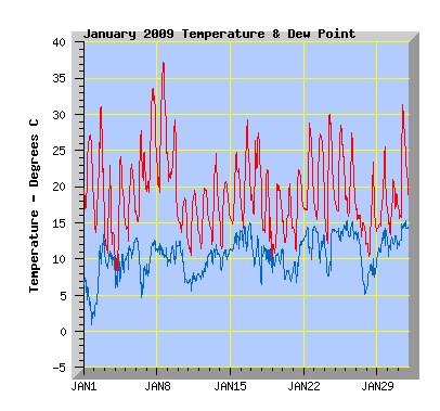
Temperature: With a mean temperature for the month of 18.6C, this was the warmest January I've recorded. The previous record was held by Jan 2004 with 18.4C. The warmest day was the 8th with a scorching 37.2C, a new record maximum temperature for my station to date and reported in the media to be the warmest day since 1998. Coldest temperature was 7.6C on the 4th. The coldest January temperature I've recorded is 3.5C on 15th Jan 2003 following a southerly the previous day. There were 27 days when the temperature was at or above 20C, equaling my 2006 record. My average is 20. There were 15 days when the temperature was at or above 25C, equaling by 2006 record. My average 9. There were 5 days where the temperature was at or above 30C, equaling my previous record in 2004. This Jan holds the record for 1 day at or over 35C.
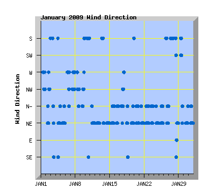
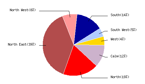
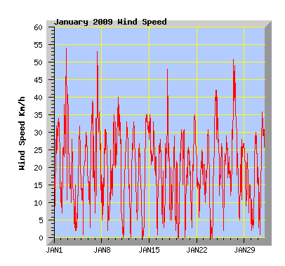
Wind: (Records from 2001) The monthly wind run of 5415km less then my January average of 5840km and the least windy January I've recorded by a very small margin. January 2005 had a wind run of 5430, just 15km more. The windiest January was 2008 with 6326km. Prevailing wind direction was north east recorded 43% of the month, north 21%, south 16%, north west 9%, south west 5%, west 5% and south east and east 1% each. Maximum gust was 54km/h from the nor'west on the 2nd.
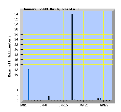
Rainfall: I missed 2 significant rainfall events in the month, 1 due to the rain gauge having a spider in it on the 3rd and the other a thunder storm on the 18th where a very close lightning strike locked up the micro that reads the weather instruments. Due to this, totals for these days has been taken from a rain gauge I have on the fence and entered into the weather station database manually to make up the total for the month. This January is the wettest I've recorded by a small margin with 49.2mm on 5 rain days, just exceeding my previous record of 48mm in Jan 2003. Overall, January has been a dry month as 46mm of this total fell on 2 days and just 3.2mm dispersed through the month over 3 days. My January average is 30.7mm over 8 days.The driest January I've recorded was 2007 with 15.4mm over 8 days.
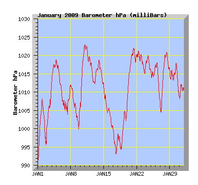
Barometer: (Records from 2006) The average pressure for the month was close to average for January at 1011.1, my average being 1011.4. The lowest pressure was recorded on the 1st, 991.1 hPa the highest minimum pressure for January I've recorded. The highest pressure was 1023.1 the lowest maximum pressure I've recorded for January. The highest January pressure is 1029.9 in 2008 and the lowest 972.3 in 2006.
| January 2009 Summary Temperature |
|
|---|---|
| Mean | 18.6 C |
| Mean Maximum | 25.4 C |
| Mean Minimum | 12.9 C |
| Maximum High | 37.2 C (8th) |
| Maximum Low | 18.4 C (8th) |
| Minimum High | 17.0 C (27th) |
| Minimum Low | 7.6 C (4th) |
| Wind Speed and Direction | |
| Maximum Gust | 54 km/h (2nd) |
| Mean | 7.4 km/h |
| Wind Run | 5415 km |
| Max Daily Windrun | 318 km (27th) |
| Prevailing Direction | North East |
| Barometer | |
| Maximum | 1023.1 hPa (11th) |
| Minimum | 991.1 hPa (1st) |
| Mean | 1011.1 hPa |
| Max Daily Change | +17.5 hPa (10th) |
| Rainfall | |
| Days with Measured Rainfall (Greater than 0.2mm) | 5 |
| Max Daily Rainfall | 34.0 mm (18th)[See Note] |
| Monthly Rainfall | 49.2 mm [See Note] |
| Humidity | |
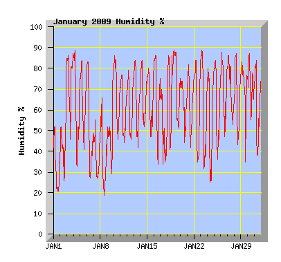
| Maximum | 89 % (Several Days) |
| Minimum | 17 % (8th) |
| January Daily Observations | ||||||||||||
|---|---|---|---|---|---|---|---|---|---|---|---|---|
| Temperature | Wind | Rainfall | Barometer | |||||||||
| Date | Min | Max | Mean | Mean (Km/h) | Gust (Km/h) | Run (km) | Prevailing Dir | 10 Minute Max (mm) | Total (mm) | Min (hPa) | Max (hPa) | Change (hPa) |
| 1 | 15.3 | 27.2 | 21.6 | 7.5 | 34 | 179 | North West | 0 | 0 | 991.2 | 1008.2 | +17.0 |
| Clear and sunny with a few patches of cloud with west to nor'west winds. | ||||||||||||
| 2 | 12.9 | 31.0 | 20.5 | 9.5 | 54 | 225 | North | 0 | 0 | 995.0 | 1007.8 | -12.8 |
| High cloud in the morning with northerly winds. Cloud clearing for a time in the afternoon then returning with gusty nor'west to west winds. A cooler southerly change later in the evening with a few light showers. | ||||||||||||
| 3 | 10.0 | 22.9 | 13.6 | 6.7 | 40 | 158 | South | - | 12.2 | 1000.1 | 1013.0 | +12.9 |
| Southerly winds with cloud but some sunny breaks in the morning. Thunder storms arrived by mid afternoon with heavy rain and a small amount of hail. A large number of lightning strikes observed to the south and west. Some thunder was very loud. The best storm in Christchurch in some time. The rain gauge failed at the beginning of the storm so the total of 12mm comes from a small rain gauge mounted on the fence. | ||||||||||||
| 4 | 7.6 | 24.1 | 15.6 | 4.7 | 32 | 110 | North East | 0 | 0 | 1013.2 | 1019.0 | +5.8 |
| High cloud in the morning clearing my midday. Sunny with some cloud in the afternoon with mostly light NE winds. | ||||||||||||
| 5 | 10.7 | 23.2 | 17.7 | 7.5 | 30 | 175 | North East | 0 | 0 | 1011.8 | 1018.5 | -6.7 |
| Sunny with a little high cloud, NE winds. | ||||||||||||
| 6 | 14.9 | 27.8 | 20.3 | 6.3 | 39 | 147 | North West | 0 | 0 | 1005.1 | 1011.7 | -6.6 |
| Sunny morning, high cloud thickening and becoming cooler in the afternoon with a few spots of rain. | ||||||||||||
| 7 | 17.5 | 33.6 | 26.0 | 9.9 | 53 | 232 | North West | 0 | 0 | 1004.0 | 1012.3 | +8.3 |
| Sunny with some high cloud. Gusty nor'west winds in the morning easing in the afternoon. A new record mean temperature for my station today, the previous record being 24.4C on the 9th Jan 2004. | ||||||||||||
| 8 | 18.4 | 37.2 | 27.5 | 5.0 | 31 | 118 | North West | 0 | 0 | 1005.8 | 1012.0 | -6.2 |
| A new record maximum and average temperature for my station. Officially 35.7C at the airport and the warmest day since 24 March 1998 when 35.9C was recorded at the airport. Sunny morning and early afternoon, high cloud increasing from mid afternoon. Mostly light west to nor'west winds. | ||||||||||||
| 9 | 15.1 | 29.2 | 22.0 | 6.0 | 35 | 140 | North | 0 | 0 | 999.9 | 1006.8 | -6.9 |
| Overcast with high cloud, north to nor'west winds. A cooler southerly change after 7pm but remaining dry. | ||||||||||||
| 10 | 11.6 | 18.5 | 15.3 | 12.3 | 40 | 290 | South | 0.6 | 1.4 | 1005.2 | 1022.7 | +17.5 |
| Morning shower then dry and sunny in the afternoon. Cool southerly winds easing in the evening. | ||||||||||||
| 11 | 9.0 | 19.6 | 14.9 | 6.7 | 33 | 159 | North East | 0 | 0 | 1018.2 | 1023.1 | -4.9 |
| Sunny with a few clouds and a NE wind. | ||||||||||||
| 12 | 10.7 | 19.8 | 15.8 | 7.5 | 33 | 177 | North East | 0 | 0 | 1012.8 | 1019.7 | -6.9 |
| Some cloud morning and evening but mostly sunny with NE winds. | ||||||||||||
| 13 | 11.8 | 24.6 | 17.2 | 4.9 | 27 | 115 | South | 0 | 0 | 1012.3 | 1018.7 | +6.4 |
| Broken cloud, southerly winds turning NE late afternoon. | ||||||||||||
| 14 | 11.1 | 20.7 | 16.4 | 8.7 | 35 | 204 | North East | 0 | 0 | 1012.1 | 1018.9 | -6.8 |
| Sunny with thin high cloud from mid afternoon, NE winds. | ||||||||||||
| 15 | 14.8 | 24.8 | 19.1 | 10.8 | 35 | 255 | North East | 0 | 0 | 1004.3 | 1012.0 | -7.7 |
| High cloud but mostly sunny. Mild with NE winds. | ||||||||||||
| 16 | 13.7 | 29.3 | 20.4 | 5.5 | 28 | 129 | North | 0 | 0 | 1000.0 | 1005.8 | -5.8 |
| High overcast for most of the day but thinning at times with sun filtering through. Mild northerly winds. | ||||||||||||
| 17 | 15.0 | 27.5 | 21.4 | 6.6 | 48 | 156 | North | 0 | 0 | 992.8 | 1000.0 | -7.2 |
| Overcast with high cloud for most of the day. Mild north to nor'west winds, gusty at times. | ||||||||||||
| 18 | 9.3 | 22.4 | 15.4 | 3.4 | 29 | 80 | North East | - | 34.0 | 992.1 | 998.7 | -6.6 |
| Mostly cloudy with variable winds in the morning. Light shower before a thunderstorm from 4:30pm with heavy rain and some hail. When it looked like this was easing, the rain increased along with hail up to 10mm in diameter. Frequent lightning strikes, one very close to my house disabled the weather station at around 5:07pm when the heaviest rain was falling. There was surface flooding in my street but no other damage evident. The total of 34mm was from a rain gauge mounted on the fence and is the total from 4:30 to 5:30pm. | ||||||||||||
| 19 | 9.5 | 20.4 | 15.3 | 6.3 | 31 | 149 | North East | 0.2 | 0.2 | 998.5 | 1006.6 | +8.1 |
| Overcast with some light showers in the morning. Cloud breaking in the afternoon with NE winds. | ||||||||||||
| 20 | 12.1 | 20.4 | 14.9 | 7.5 | 31 | 176 | North | 0 | 0 | 1007.0 | 1020.4 | +13.4 |
| Overcast for most of the day with north to NE winds. Cloud breaking in the evening. | ||||||||||||
| 21 | 10.4 | 22.3 | 17.0 | 8.4 | 35 | 198 | North East | 0 | 0 | 1018.2 | 1022.1 | -3.9 |
| Some high cloud but mostly sunny and mild with NE winds. | ||||||||||||
| 22 | 16.6 | 28.9 | 20.9 | 6.3 | 25 | 148 | North | 0 | 0 | 1018.5 | 1021.5 | -3.0 |
| High overcast breaking late morning and becoming sunny and warm with north to NE winds. | ||||||||||||
| 23 | 13.9 | 27.3 | 21.2 | 7.4 | 31 | 174 | North | 0 | 0 | 1015.0 | 1020.0 | -5.0 |
| Morning mist. Clear, warm and sunny with north to NE winds. | ||||||||||||
| 24 | 11.6 | 30.1 | 20.3 | 7.6 | 42 | 180 | North East | 0 | 0 | 1015.9 | 1020.0 | -4.1 |
| Some wispy high cloud with light northerly winds in the morning. Temperature reached 30.1C at 11:10am. A cooler NE wind strengthening during the afternoon with clear skies. | ||||||||||||
| 25 | 16.4 | 28.5 | 21.6 | 7.8 | 34 | 183 | North East | 0 | 0 | 1014.0 | 1017.5 | +3.5 |
| Sunny and warm with north to NE winds. High cloud increasing later in the afternoon. | ||||||||||||
| 26 | 15.8 | 27.4 | 19.6 | 9.7 | 29 | 230 | South | 0 | 0 | 1006.5 | 1018.1 | -11.6 |
| Low cloud breaking and clearing by late morning, thin high cloud later in the day. Southerly winds turning NE later in the afternoon. | ||||||||||||
| 27 | 11.6 | 17.0 | 14.3 | 13.4 | 51 | 318 | South | 0.2 | 0.6 | 1004.5 | 1020.1 | +15.6 |
| Morning light showers with a cool southerly wind. Showers clearing by midday but remaining mostly cloudy and cool. Maximum temperature recorded at 1am before the cooler southerly air arrived. | ||||||||||||
| 28 | 10.3 | 23.4 | 14.4 | 6.4 | 28 | 151 | North East | 0.2 | 0.8 | 1016.2 | 1021.0 | -4.8 |
| Morning showers. Cloud breaking late morning. Wind turning NE after noon with variable high cloud. | ||||||||||||
| 29 | 13.9 | 25.5 | 17.3 | 5.5 | 24 | 129 | North East | 0 | 0 | 1013.1 | 1016.2 | -3.1 |
| Overcast with high cloud and a few spots of rain at times during the day. Light southerly winds turning NE later in the afternoon | ||||||||||||
| 30 | 12.4 | 21.0 | 16.7 | 5.8 | 30 | 138 | North East | 0 | 0 | 1008.8 | 1018.1 | -9.3 |
| Mostly overcast with high cloud but the cloud breaking for a while early afternoon and again in the evening. NE wind. | ||||||||||||
| 31 | 15.1 | 31.4 | 21.6 | 7.5 | 36 | 177 | North East | 0 | 0 | 1008.0 | 1012.2 | +4.2 |
| Very warm in the morning with the maximum temperature for the day recorded at 10:30am. A NE breeze came up a few minutes later and provided some cooling for the remainder of the day. Cloud increasing from late afternoon. | ||||||||||||