My January
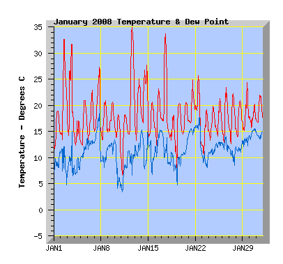
Temperature: This January was the second warmest I've recorded and also set a new maximum temperature record for my station of 34.9C on the 12th, exceeding the previous record set on 15th Jan 2005 by 0.1C. The coldest January temperature was 5.8C in the 11th. The coldest January temperature I've recorded was 3.5C on the 15th January 2003. The average temperature was 17.6C, above the January average of 16.1C from 9 years of records. January had 4 days at or over 30C, January 2004 currently holds my record with 5 days at or over 30C. The warmest January was 2004 with an average of 18.4C. The coolest average for January was 2001 with 13.4C.
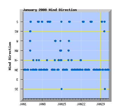
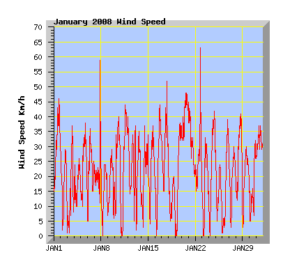
Wind: With a wind run of 6326km, this is the windiest January I've recorded with records from 2001. The average January wind run is 5901km. The least windy January was 2005 with 5430km. Highest gust was 63km/h from the south on the 22nd. Prevailing direction was north east 71% of the month, south 18%, north 3%, west 2%, south west 2%, north west 2% and south east 1%.
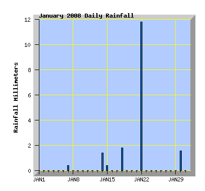
Rainfall: I recorded 6 days of rainfall (more than 0.2m), my January average is 8 days. Total rainfall of 17.4mm for the month with a January average of 28mm. This is the second driest January I've recorded, the driest being 2007 with 15.4mm. The wettest January was 2003 with 48mm. My January records go back to 2000 unless otherwise noted.
| January 2008 Summary Temperature |
|
|---|---|
| Mean | 17.6 C |
| Mean Maximum | 23.2 C |
| Mean Minimum | 12.8 C |
| Maximum High | 34.9 C (12th) |
| Maximum Low | 16.6 C (31st) |
| Minimum High | 17.0 C (4th) |
| Minimum Low | 5.8 C (11th) |
| Wind Speed and Direction | |
| Maximum Gust | 63 km/h (8th) |
| Mean | 8.6 km/h |
| Wind Run | 6326 km |
| Max Daily Windrun | 408 km (20th) |
| Prevailing Direction | North East |
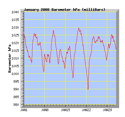
| Barometer | |
| Maximum | 1029.9 hPa (19th) |
| Minimum | 989.7 hPa (22nd) |
| Mean | 1015.8 hPa |
| Max Daily Change | +17.1 hPa (22nd) |
| Rainfall | |
| Days with Measured Rainfall (Greater than 0.2mm) | 6 |
| Max Daily Rainfall | 11.8 mm (22nd) |
| Monthly Rainfall | 17.4 mm |
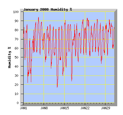
| Humidity | |
| Maximum | 94 % (6th) |
| Minimum | 17 % (17th) |
| January Daily Observations | ||||||||||||
|---|---|---|---|---|---|---|---|---|---|---|---|---|
| Temperature | Wind | Rainfall | Barometer | |||||||||
| Date | Min | Max | Mean | Mean (Km/h) | Gust (Km/h) | Run (km) | Prevailing Dir | 10 Minute Max (mm) | Total (mm) | Min (hPa) | Max (hPa) | Change (hPa) |
| 1 | 11.7 | 19.0 | 15.4 | 12.7 | 46 | 301 | North East | 0 | 0 | 1016.9 | 1026.9 | -10.0 |
| Sunny with some thin high cloud at times. Fresh and gusty NE wind. | ||||||||||||
| 2 | 12.4 | 32.7 | 21.4 | 6.0 | 29 | 143 | North East | 0 | 0 | 1010.5 | 1017.3 | -6.8 |
| Very warm with light breezes in the morning. A cooler NE wind in the afternoon. | ||||||||||||
| 3 | 14.0 | 31.8 | 20.2 | 4.4 | 37 | 104 | West | 0 | 0 | 1007.0 | 1020.0 | +13.0 |
| High cloud with light breezes and warm temperatures in the morning. Nor'west winds in the afternoon changing to cooler southerly winds and clearing skies. | ||||||||||||
| 4 | 12.4 | 17.0 | 14.2 | 6.4 | 26 | 152 | North East | 0 | 0 | 1020.3 | 1026.2 | +1.9 |
| Cloudy and cool for most of the day with a few spots of rain in the afternoon. NE winds. | ||||||||||||
| 5 | 10.8 | 20.9 | 16.5 | 9.3 | 38 | 221 | North East | 0 | 0 | 1018.3 | 1025.7 | -7.4 |
| Clear and sunny with NE winds. | ||||||||||||
| 6 | 12.7 | 22.9 | 17.0 | 9.8 | 36 | 231 | South | 0 | 0 | 1014.4 | 1020.6 | -6.2 |
| Low cloud with southerly winds clearing by late morning leaving some high cloud. Low cloud returning in the evening. | ||||||||||||
| 7 | 14.9 | 27.4 | 19.5 | 9.1 | 59 | 214 | North East | 0.2 | 0.4 | 1000.8 | 1014.1 | -13.3 |
| Morning rain with NE winds clearing but remaining overcast. Maximum temperature recorded at 6:30pm. A change to strong cool southerly winds in the evening but remaining dry. | ||||||||||||
| 8 | 13.0 | 20.9 | 16.8 | 5.6 | 24 | 132 | North East | 0 | 0 | 1007.7 | 1012.9 | -5.2 |
| Overcast in the morning. Cloud breaking in the afternoon then sunny with light NE winds. | ||||||||||||
| 9 | 14.7 | 20.7 | 17.2 | 6.0 | 29 | 141 | North East | 0 | 0 | 1006.8 | 1012.8 | -6.0 |
| Overcast for most of the day with NE winds. Cloud breaking mid afternoon and clearing for a time but returning in the evening with a southerly change. | ||||||||||||
| 10 | 9.5 | 18.2 | 14.9 | 10.5 | 40 | 246 | South | 0 | 0 | 1012.5 | 1028.3 | +15.8 |
| Morning cloud breaking and clearing by afternoon. Cooler southerly winds easing in the evening. | ||||||||||||
| 11 | 5.8 | 18.3 | 13.7 | 10.3 | 44 | 244 | North East | 0 | 0 | 1015.9 | 1027.9 | -12.0 |
| Clear and sunny with a gusty NE wind. | ||||||||||||
| 12 | 14.3 | 34.9 | 24.0 | 8.1 | 40 | 191 | North East | 0 | 0 | 1006.2 | 1015.7 | -9.5 |
| Clear and sunny with NE winds in the morning and hot nor'west winds in the afternoon. Record maximum temperature for my station to date, exceeding the previous record of 34.8C set on the 15th January 2005. The daily average temperature is the second highest I've recorded with the current record being 24.4C on the 19th January 2004. | ||||||||||||
| 13 | 13.1 | 25.0 | 19.2 | 8.0 | 37 | 189 | North East | 0 | 0 | 1010.5 | 1016.3 | -5.8 |
| Some high cloud for much of the day but mostly sunny and warm with NE winds. | ||||||||||||
| 14 | 15.0 | 27.8 | 21.6 | 6.7 | 37 | 160 | North West | 0.8 | 1.4 | 1003.1 | 1010.4 | -7.3 |
| Mostly overcast with high cloud and light breezes for much of the day. Cloud breaking for a time later afternoon with warm nor'west winds with 27.8C at 7pm. Cloud increases again with a southerly change and a few showers in the evening. | ||||||||||||
| 15 | 13.8 | 20.7 | 16.8 | 8.7 | 37 | 205 | North East | 0.2 | 0.4 | 1009.5 | 1016.5 | +7.0 |
| Overcast with morning drizzle. Cloud breaking and clearing in the afternoon. NE winds. | ||||||||||||
| 16 | 11.2 | 23.2 | 17.7 | 9.4 | 44 | 223 | North East | 0 | 0 | 1007.4 | 1018.0 | -10.6 |
| Broken morning cloud clearing to a sunny day but some low cloud returning in the evening. Fresh Ne wind. | ||||||||||||
| 17 | 14.8 | 33.7 | 21.8 | 12.7 | 52 | 299 | North East | 0 | 0 | 997.3 | 1012.1 | +14.8 |
| Clear, sunny and very warm in the morning and afternoon with west to nor'west winds. Cloud increasing with a cooler southerly change later in the afternoon followed by stronger southerly winds in the evening with some drizzle. This was the 7th day at or over 30C this summer, the previous record was 6 days for the summer 2003 - 2004. It was also the second hottest day of this summer to date. | ||||||||||||
| 18 | 11.4 | 18.1 | 14.8 | 4.2 | 23 | 99 | North East | 1.0 | 1.8 | 1012.1 | 1025.4 | +13.3 |
| Cloudy and cool for much of the day with morning showers and drizzle. Cloud breaking in the afternoon with sunny intervals. Light NE winds. | ||||||||||||
| 19 | 7.3 | 20.4 | 15.3 | 8.3 | 38 | 196 | North East | 0 | 0 | 1025.5 | 1029.9 | +4.4 |
| Sunny with a few clouds, NE winds. | ||||||||||||
| 20 | 14.5 | 20.6 | 17.3 | 17.3 | 48 | 408 | North East | 0 | 0 | 1017.9 | 1028.1 | -10.2 |
| Cloud morning and evening. Gusty NE wind. Windiest day since April 13th 2007. | ||||||||||||
| 21 | 16.5 | 24.9 | 19.2 | 12.3 | 45 | 290 | North East | 0 | 0 | 1002.5 | 1017.7 | -15.2 |
| NE wind easing during the day. Overcast with drizzle in the morning, low cloud clearing with broken high cloud in the afternoon. Overcast in the evening with a few spots of rain. | ||||||||||||
| 22 | 12.3 | 25.8 | 18.3 | 11.3 | 63 | 267 | North East | 1.0 | 11.8 | 989.7 | 1006.8 | +17.1 |
| Mild north to nor'east wind in the morning with isolated showers. Rain from afternoon with a strong cold southerly change later in the afternoon. | ||||||||||||
| 23 | 10.0 | 19.2 | 14.7 | 6.0 | 33 | 143 | North East | 0 | 0 | 1006.9 | 1021.3 | +14.4 |
| Overcast through to mid afternoon. Cloud breaking but returning in the evening.NE winds. | ||||||||||||
| 24 | 12.9 | 19.8 | 16.2 | 8.9 | 42 | 210 | North East | 0 | 0 | 1020.2 | 1024.1 | -3.9 |
| Some morning drizzle. Cloud breaking about midday. NE winds. | ||||||||||||
| 25 | 13.5 | 21.4 | 16.9 | 5.5 | 24 | 129 | South | 0 | 0 | 1020.0 | 1023.8 | +3.8 |
| Overcast with light southerly winds. | ||||||||||||
| 26 | 12.8 | 23.5 | 17.3 | 6.3 | 39 | 150 | North East | 0 | 0 | 1020.4 | 1024.0 | -3.6 |
| Morning mist with low cloud and a few spots of rain. Cloud lifting and breaking in the afternoon. NE wind from afternoon. | ||||||||||||
| 27 | 11.9 | 22.3 | 17.3 | 6.7 | 30 | 157 | North East | 0 | 0 | 1017.5 | 1021.7 | -4.2 |
| Sunny with broken cloud and NE winds. | ||||||||||||
| 28 | 13.9 | 20.9 | 17.3 | 10.2 | 41 | 241 | North East | 0 | 0 | 1008.7 | 1017.3 | -8.6 |
| Broken morning cloud clearing to a sunny day. Cloud increasing again in the evening. NE winds. | ||||||||||||
| 29 | 14.8 | 24.4 | 18.2 | 8.3 | 30 | 197 | South | 0 | 0 | 1011.3 | 1019.4 | +8.1 |
| Morning cloud breaking by midday then sunny. Southerly winds turning NE later in the afternoon. | ||||||||||||
| 30 | 15.6 | 20.3 | 17.6 | 5.1 | 32 | 121 | North East | 0.4 | 1.6 | 1018.6 | 1025.7 | +7.1 |
| Overcast with light rain and drizzle. Light southerly winds turning NE later in the afternoon with cloud breaking. | ||||||||||||
| 31 | 16.6 | 22.0 | 18.8 | 13.0 | 37 | 306 | North East | 0 | 0 | 1015.2 | 1023.9 | -8.7 |
| Some cloud, mostly sunny, fresh NE winds. | ||||||||||||